Arsip | Maret, 2013

Gunung Bromo

15 Mar

Wikipedia bahasa Indonesia, ensiklopedia bebas

Gunung Bromo

Gunung Bromo (latar depan, kawah besar) saat matahari terbitKetinggian: 2.329 m (7.641 ft)
Gunung Bromo (latar depan, kawah besar) saat matahari terbit
Ketinggian: 2.329 m (7.641 ft)

Gunung Bromo (dari bahasa Sanskerta: Brahma, salah seorang Dewa Utama Hindu), merupakan gunung berapi yang masih aktif dan paling terkenal sebagai obyek wisata di Jawa Timur. Sebagai sebuah obyek wisata, Gunung Bromo menjadi menarik karena statusnya sebagai gunung berapi yang masih aktif.

800px-Indonesia_relief_location_map
Bromo mempunyai ketinggian 2.392 meter di atas permukaan laut itu berada dalam empat wilayah, yakni Kabupaten Probolinggo, Pasuruan, Lumajang, dan Kabupaten Malang. Bentuk tubuh Gunung Bromo bertautan antara lembah dan ngarai dengan kaldera atau lautan pasir seluas sekitar 10 kilometer persegi.

Gunung Bromo mempunyai sebuah kawah dengan garis tengah ± 800 meter (utara-selatan) dan ± 600 meter (timur-barat). Sedangkan daerah bahayanya berupa lingkaran dengan jari-jari 4 km dari pusat kawah Bromo.

Sejarah Letusan

Selama abad XX, gunung yang terkenal sebagai tempat wisata itu meletus sebanyak tiga kali, dengan interval waktu yang teratur, yaitu 30 tahun. Letusan terbesar terjadi 1974, sedangkan letusan terakhir terjadi pada 2010.

Sejarah letusan Bromo: 2011, 2010, 2004, 2001, 1995, 1984, 1983, 1980, 1972, 1956, 1955, 1950, 1948, 1940, 1939, 1935, 1930, 1929, 1928, 1922, 1921, 1915, 1916, 1910, 1909, 1907, 1908, 1907, 1906, 1907, 1896, 1893, 1890, 1888, 1886, 1887, 1886, 1885, 1886, 1885, 1877, 1867, 1868, 1866, 1865, 1865, 1860, 1859, 1858, 1858, 1857, 1856, 1844, 1843, 1843, 1835, 1830, 1830, 1829, 1825, 1822, 1823, 1820, 1815, 1804, 1775, dan 1767.

Bromo sebagai gunung suci

Bagi penduduk Bromo, suku Tengger, Gunung Brahma (Bromo) dipercaya sebagai gunung suci. Setahun sekali masyarakat Tengger mengadakan upacara Yadnya Kasada atau Kasodo. Upacara ini bertempat di sebuah pura yang berada di bawah kaki Gunung Bromo utara dan dilanjutkan ke puncak gunung Bromo. Upacara diadakan pada tengah malam hingga dini hari setiap bulan purnama sekitar tanggal 14 atau 15 di bulan Kasodo (kesepuluh) menurut penanggalan Jawa.


Caldera Rafting (Arung Jeram)

11 Mar

Caldera Rafting (Arung Jeram) 

ABOUT US

Berangkat dari keinginan yang kuat untuk dapat mewujudkan sebuah arena bermain sambil berpetualang dengan mengambil latar belakang suasana pedesaan yang alami.
CALDERA 1-ddd2559980f1PT .Caldera Indonesia dengan berbagai produknya antara lain Caldera Ed-Venture (Outing & pelatihan), Caldera Resort, Caldera rafting dan Kampoeng Maen dan caldera journey mengemas konsep Outdor Experiental Education yang dapat menampung anak-anak usia dini, remaja hingga dewasa.

CALDERA RIAM JERAM

Program-program yang kami sajikan telah kami kemas sedemikian rupa dalam bentuk permainan-permainan yang menyajikan permasalahan yang unik.

CALDERA 4Melalui permainan-permainan tersebut dan dengan dipandu oleh fasilitator / pembimbing yang telah berpengalaman akan melatih peserta untuk mengenal kemampuan dirinya, melatih kemandirian, merangsang keberanian sehingga hal tersebut secara langsung akan memotivasi daya pikir peserta untuk lebih peka terhadap lingkungan sekitar serta menghargai individu lainnya sebagai sebuah tim.
CALDERA 3
CALDERA INDONESIA Pusat kegiatan Outbound, Adventure dan Arung Jeram terlengkap di IndonesiaFasilitas yang tersedia di CALDERA INDONESIA :

  • Caldera Edventure (Pusat kegiatan pelatihan Outbound untuk perorangan dan perusahaan)
  • Caldera Rafting (Arung Jeram yang seru dan menantang)
  • Kampoeng Maen (Perpaduan dunia hiburan dan pendidikan melalui aktifitas luar ruang untuk anak-anak). PT.Caldera Indonesia mempunyai lahan di Citarik Sukabumi, arena kampoeng maen di bumi perkemahan Cibubur

Dengan konsep EXPERIENTIAL LEARNING: Learning is Fun! Rangkaian permainan (Outdoor dan Indoor Activies) yang adventurous dan menyenangkan hanya akan dapat ditemukan di tempat kami!

CONTACT INFORMATION FOR RAFTING

  • GATOT 081586417151
  • ANNY 081563473839
  • FERRY 081233133607

Cikidang Hunting Resort

11 Mar

Monday, 15 March 2010 14:31 | Jurnal Berburu

Cikidang Hunting Resort

cikidang2Memasuki wilayah ini, pertama yang akan Anda lihat adalah perkebunan sawit yang tampak terawat. Namun sesungguhnya ini bukan semata perkebunan kelapa sawit. Di sini merupakan area wisata berburu satu-satunya di Indonesia.

Konsepnya, hampir mirip dengan ladang perburuan di Afrika atau Australia. Hanya bedanya, binatang di Afrika lebih lengkap dibandingkan di Cikidang. “Di Afrika, jumlah binatang itu lebih banyak dibandingkan orang,” ujarnya.
Cikidang Hunting Resort terletak di tengah perkebunan teh , karet, dan kelapa sawit di Desa Pangkalan, Kecamatan Cikidang, Kabupaten Sukabumi, Jawa Barat. Area wisata berburu ini bisa berjarak sekitar 100 km dari Jakarta. Para hunter tak perlu khawatir dengan kendaraannya, karena jalan menuju lokasi perburuan ini berupa hotmix dan mulus.

Nah, bagi Anda yang hobi berburu, tampaknya Cikidang Hunting Resort tempat yang cocok untuk berkunjung. Tentu saja, untuk bisa menikmati hobi beburu di sini Anda harus merogoh kocek sedikit dalam.

cikidang1Di sini, Anda bisa berburu sambil menikmati indahnya alam pegunungan yang masih asri. Untuk berburu di sini, Anda tak perlu repot untuk memabawa senjata sendiri. Semua jenis senapan berburu tersedia di sini dengan ongkos sewa cukup terjangkau. Hanya saja, senapan yang digunakan bukanlah senapan peluru tajam, melainkan senapan angin dengan kaliber 4.5.

Target buruannya pun beragam, mulai dari babi hutan, ayam kalkun, kelinci, kambing liar, dan bebek. Tiap target buruan memiliki harga yang berbeda. “Orang berpikir babi hutan tidak mati ditembak dengan senapan angin. Tapi di sini bisa dibuktikan, asal nembaknya tepat sasaran,” kata Budi Handoko, pemilik wisata berburu ini.

Jika ingin tantangan yang lebih, pengunjung juga bisa menggunakan panah dengan anak panah yang tajam. Di sini juga tersedia mobil berburu 4×4. Berkapasitas lima tempat duduk, dengan rak memuat beban hingga 450 kg untuk binatang buruan. Ada juga motor jenis ATV, si mungil yang gesit di segala medan ekstrim.

KONICA MINOLTA DIGITAL CAMERAUntuk melengkapi kenyamanan saat wisata berburu, Cikidang Hunting Resort juga menyediakan penginpan dengan berbagai pilihan tipe, restoran, kolam renang, wisata kuda, permainan perang-perangan (airsoft gun), dan lapangan tembak untuk latihan.

Menurut Budi Handoko, selama ini, animo wisata berburu di sini cukup besar. Bukan hanya pemburu dari dalam negeri, tetapi juga dari luar negeri seprti Austrlia, china, dan Arab Saudi. Nah, Anda ingin coba berpetualang sambil berburu? (A. Kholis)

Citarik Rafting Sukabumi

10 Mar

Citarik Rafting Sukabumi

Rafting atau arung jeram di Sungai Citarik, Sukabumi sudah sangat populer dikalangan pecinta aktivitas luar ruangan. Rafting di Sungai Citarik sangatlah cocok untuk mengisi waktu liburan anda terutama bila anda suka memacu adrenalin. Kegiatan ini dapat dinikmati oleh semua kalangan dari anak-anak, dewasa, pria, dan wanita karena sistem keamanan dan peralatan yang disediakan sudah berstandar internasional.

Untuk anak-anak, usia minimal yang disarankan adalah 12 tahun, dan untuk dewasa usia maksimum yang disarankan adalah 65 tahun. Peserta rafting juga harus memiliki badan yang sehat, terutama untuk aktifitas fisik di luar ruangan, dan tidak boleh memiliki catatan medis jantung, asma, dan epilepsi.

Selain sistem keamanan berupa rescue team atau tim penyelamat yang terlatih dan bersertifikat, guide rafting terlatih, dan peralatan yang sesuai standar internasional, seluruh paket juga sudah termasuk fasilitas asuransi yang terpercaya sehingga tidak perlu takut untuk mencoba rafting di Sungai Citarik karena keamanan, kesenangan, dan kepuasan anda adalah prioritas utama kami.

  • Jembatan sungai Citarik
  • Serunya Rafting Citarik
  • Penginapan Citarik
  • Rafting Citarik 4
  • Sungai Citarik
  • Restorant Citarik
  • Siap-siap rafting Citarik
  • Peralatan rafting Citarik
  • Restaurant Citarik
  • Jembatan sungai Citarik
  • Serunya Rafting Citarik
Harga mulai dari Rp.230.000
Rafting atau arung jeram di Sungai Citarik, Sukabumi sudah sangat populer dikalangan pecinta aktivitas luar ruangan. Rafting di Sungai Citarik sangatlah cocok untuk mengisi waktu liburan anda terutama bila anda suka memacu adrenalin. Kegiatan ini dapat dinikmati oleh semua kalangan dari anak-anak, dewasa, pria, dan wanita karena sistem keamanan dan peralatan yang disediakan sudah berstandar internasional.Untuk anak-anak, usia minimal yang disarankan adalah 12 tahun, dan untuk dewasa usia maksimum yang disarankan adalah 65 tahun. Peserta rafting juga harus memiliki badan yang sehat, terutama untuk aktifitas fisik di luar ruangan, dan tidak boleh memiliki catatan medis jantung, asma, dan epilepsi.

Selain sistem keamanan berupa rescue team atau tim penyelamat yang terlatih dan bersertifikat, guide rafting terlatih, dan peralatan yang sesuai standar internasional, seluruh paket juga sudah termasuk fasilitas asuransi yang terpercaya sehingga tidak perlu takut untuk mencoba rafting di Sungai Citarik karena keamanan, kesenangan, dan kepuasan anda adalah prioritas utama kami.

Daftar Paket

CITARIK RAFTING-HARGA PAKET

Fasilitas :

  • Transportasi dari meeting point ke start point
  • Transportasi dari finish point ke meeting point
  • Perlengkapan berstandar internasional
  • Guide rafting
  • Rescue team
  • Welcome drink (kopi, teh, air mineral) sebelum rafting
  • 1x Makan setelah rafting
  • Kelapa muda setelah rafting
  • Shower
  • Asuransi
  • Sertifikat rafting
  • Foto rafting (akan dikenakan biaya tambahan bila ingin mengambil foto)

Punya Pertanyaan?

Email : marketing@jajalindo.com Atau Hubungi 021 6888 8466

Pelabuhan Ratu, Sukabumi

10 Mar

Pantai dengan Panorama Indah nan Mistis

Pantai dengan Panorama Indah nan Mistis

Pelabuhan Ratu, pantai yang terletak kurang lebih 60 km arah selatan Kota Sukabumi ini, selain terkenal dengan panoramanya yang indah, juga karena sering dikaitkan dengan hal-hal mistis.

Setiap tahun di pantai ini selalu digelar pesta laut, yakni upacara melarungkan kepala kerbau dan sesaji lainnya ke tengah laut. Tradisi ini diselenggarakan para nelayan setempat setiap tanggal 5 April setahun sekali. Tradisi ini merupakan ungkapan rasa syukur kepada Tuhan atas anugerah yang telah diberikan berupa hasil tangkapan ikan.

Selain pesta laut, juga ada ritual lain yang juga diselenggarakan setiap tahun, yaitu ritual mandi suci atau ngabungbang. Kata ngabungbang berasal dari “nga” yang berarti ngahijikan (menyatukan) dan “bungbang” yang berarti membuang atau membersihkan.

Ritual ini berarti mandi suci untuk menghilangkan unsur-unsur buruk, lahir-batin. Selain itu, ritual ini juga dimaksudkan sebagai sarana memohon ampunan Tuhan meminta kekuatan agar tercapai segala cita-cita serta mengharapkan peningkatan kualitas hidup.

Tradisi tahunan ini diselenggarakan pada dini hari saat bulan purnama tanggal 14 bulan Maulud, dan berlokasi di muara Sungai Cisukawayana, Pantai Pelabuhan Ratu. Menurut beberapa sumber, awalnya tradisi ini diciptakan Raja Hyang Brahma dari Kerajaan Medang Gali (galuh) pada 175 – 205 Masehi. Ritual ini kemudian diteruskan Prabu Siliwangi dari Kerajaan Pajajaran dan berkembang hingga sekarang.

Kepercayaan akan seorang ratu pantai selatan juga dikuatkan adanya sebuah kamar hotel yang dianggap sebagai tempat istirahat Ratu Laut Kidul jika sedang “mendarat”. Samudera Beach Hotel yang berada sekitar 300 meter dari pantai ini memiliki kamar bernomor 13. Kamar ini didesain dengan warna hijau dominan di seluruh isi kamarnya.

Seperti tempat tidur dengan bad cover serbahijau serta hiasan lampu dan foto besar “Nyi Roro Kidul” yang terpasang di dinding kamar. Benar-tidaknya, yang pasti masyarakat di Sukabumi sangat memercayai adanya penguasa Pelabuhan Ratu tersebut. Upaya menggambarkan keberadaan ratu pantai selatan ini juga sering dilakukan dalam kegiatan seni budaya masyarakat setempat.

Salah satunya adalah Pergelaran Budaya Kemilau Nusantara di depan Gedung Sate, Kota Bandung, akhir pekan lalu. Sebuah pergelaran seni berjudul “Ngarak Ratu Laut Kidul” menjadi salah satu sajian atraksi budaya yang banyak mendapatkan aplaus publik.

Penguasa laut selatan atau Nyi Roro Kidul tampil dengan ditandu. Busana tradisional Jabar dengan warna khas hijau tampak cantik sesuai dengan pembawaan sang ratu. Sebuah mahkota emas menjadi tanda jika dia adalah seorang ratu. Singgasana tampak mewah yang digambarkan bertatahkan emas dan berlian.

Sementara itu, para pengawalnya yang membawa tandu mengenakan busana serbaputih. Ratu cantik ini pun diiringi dayang-dayang dengan warna baju serbaputih. Atas penampilannya yang memesona tersebut, atraksi Ngarak Ratu Laut Kidul ini diganjar sebagai juara kedua pada acara Kemilau Nusantara 2012 di Kota Bandung.

Atraksi seni ini juga sebagai salah satu upaya pemerintah setempat agar masyarakat melihat Pelabuhan Ratu merupakan aset wisata yang menarik untuk dikunjungi.

Sementara itu, terkait mistis, setiap orang boleh percaya atau tidak. Namun, setidaknya kepercayaan itu dapat menjadi suguhan menarik yang dikemas dalam gelaran seni budaya setempat yang akhirnya dapat menambah daya tarik kunjungan wisatawan ke pantai ini.

Mengunjungi pantai ini, wisatawan juga dapat membawa oleh-oleh ikan segar yang baru saja ditangkap nelayan. Sebab, tidak jauh dari pantai terdapat Tempat Pelelangan Ikan (TPI) yang setiap hari, mulai pukul 10.00 hingga 13.00 WIB, ramai oleh aktivitas lelang ikan.

Nah, menikmati akhir pekan di selatan Jabar dengan pemandangan laut yang indah Pelabuhan Ratu dapat menjadi referensi. Anda dapat menikmati wisata pantai yang murah di sini. Soal keselamatan pengunjung, pengelola objek wisata ini menyiapkan sejumlah petugas pantai atau Balawista yang akan menjaga keamanan pengunjung. (tgh/R-2)

Jadi Lokasi “Surfing” Internasional

Pantai Pelabuhan Ratu juga dikenal memiliki gelombang laut yang tinggi sehingga cocok digunakan untuk olah raga surfing. Selain tinggi, pantai ini juga memiliki gelombang yang dapat bergerak cepat dan stabil.

Dengan kondisi air seperti itu, maka di pantai ini terdapat beberapa tempat surfing yang sering dikunjungi wisatawan, seperti Batu Guram, Karang Sari, Cimaja, Karang Haji, Indicator, Sunset Beach, Ombak Tujuh, dan Ujung Genteng.

Beberapa tempat surfing tersebut ramai dikunjungi wisatawan, tepatnya pada Mei hingga Oktober, saat kondisi ombak sedang tinggi.

Di Pelabuhan Ratu, setiap tahun, selalu diselenggarakan perlombaan surfing yang diikuti peselancar tingkat dunia. Seperti pada Juni lalu, berlangsung West Java Surfing Championship & Wind Surfing Exhibition 2012, di Pantai Cimaja.

Even tahunan ini, menurut Kadis Pariwisata dan Kebudayaan Jabar, Nunung Sobari, selalu menyedot animo peselancar dunia. Saat itu, surfer dari Filipina, Vietnam, Jepang, dan Malaysia ikut meramaikan perlombaan. Jumlah pesertanya bahkan mencapai 100 orang lebih.

Salah satu peserta yang akan bertanding di West Java Surfing 2012 ini, yaitu Dede Suryana, asal Sukabumi, yang sudah masuk jajaran surfer dunia.(tgh/R-2)

Objek Wisata Lain

Sebenarnya masih banyak objek wisata lain yang menarik untuk dikunjungi, beberapa di antaranya adalah Wana Wisata Cangkuang yang merupakan objek wisata alam di lereng Gunung Salak.

Karena terletak di lereng gunung, suasana alamnya masih segar dan alami. Untuk pengunjung yang tertarik terhadap wisata petualangan, pengelola telah menyiapkan camping ground dan hiking track untuk mencapai Kawah Ratu dan Air Terjun Dua Undak yang masih masuk kawasan ini.

Wisata alam lainnya adalah Wana Wisata Cipelang. Berlokasi di kaki Gunung Gede, atau sekitar 15 Km dari utara Sukabumi. Lalu ada pula Wana Wisata Gua Buniayu yakni gua alam yang terbentuk akibat pelarutan dan pengikisan air hutan terhadap lapisan batu gamping di kawasan perbukitan, yang terjadi selama ribuan tahun. Lokasinya di Desa Kertaangsana, Kecamatan Nyalindung, Kabupaten Sukabumi, ke arah Sagaranten.

Sukabumi juga memiliki banyak sungai, di antaranya ada sungai yang sudah sangat terkenal untuk kegiatan arung jeram, seperti Sungai Citarik, kurang lebih 30 km dari Kota Sukabumi. Sungai ini memiliki alur jeram terbaik dan alur yang berliku-liku ke bawah dari Gunung Halimun hingga ke persawahan dengan pemandangan hutan yang sangat indah dari kiri-kanannya. Sungai lainnya yang biasa juga dipakai untuk Arung Jeram adalah Sungai Citatih dan Sungai Cimandiri. (tgh/R-2)

BALI

10 Mar

BALI

(PULAU DEWATA)

From Wikipedia, the free encyclopedia with slight revision

This article is about the Indonesian island. For other uses, see Bali (disambiguation)

BALI peta-pulau-bali-640
Map of Bali Island

Bali is a province in the country of Indonesia. The province covers a few small neighbouring islands as well as the isle of Bali. The main island is located in the westernmost end of the Lesser Sunda Islands, lying between Java to the west and Lombok to the east. It is one of the country’s 34 provinces with the provincial capital at Denpasar towards the south of the island.

With a population recorded as 3,891,428 in the 2010 census,[3] and currently 4.22 million,[4] the island is home to most of Indonesia’s Hindu minority. In the 2000 census about 92.29% of Bali’s population adhered to Balinese Hinduism while most of the remainder follow Islam. It is also the largest tourist destination in the country and is renowned for its highly developed arts, including traditional and modern dance, sculpture, painting, leather, metalworking, and music. A tourist haven for decades, Bali has seen a further surge in tourist numbers in recent years.

History

Main article: History of Bali

BALI MAP

BALI indocom_Balinese_Dancer-150Bali was inhabited by around 2000 BC by Austronesian peoples who migrated originally from Taiwan through Maritime Southeast Asia.[5] Culturally and linguistically, the Balinese are thus closely related to the peoples of the Indonesian archipelago, Malaysia, the Philippines, and Oceania.[6] Stone tools dating from this time have been found near the village of Cekik in the island’s west.[7]

In ancient Bali, nine Hindu sects existed, namely Pasupata, Bhairawa, Siwa Shidanta, Waisnawa, Bodha, Brahma, Resi, Sora and Ganapatya. Each sect revered a specific deity as its personal Godhead.[8]

Balinese culture was strongly influenced by Indian, Chinese, and particularly Hindu culture, beginning around the 1st century AD. The name Bali dwipa (“Bali island”) has been discovered from various inscriptions, including the Blanjong pillar inscription written by Sri Kesari Warmadewa in 914 AD and mentioning “Walidwipa”. It was during this time that the complex irrigation system subak was developed to grow rice. Some religious and cultural traditions still in existence today can be traced back to this period. The Hindu Majapahit Empire (1293–1520 AD) on eastern Java founded a Balinese colony in 1343. When the empire declined, there was an exodus of intellectuals, artists, priests, and musicians from Java to Bali in the 15th century.

Tanah Lot, one of the major temples in Bali

Tanah Lot, one of the major temples in Bali

The first European contact with Bali is thought to have been made in 1585 when a Portuguese ship foundered off the Bukit Peninsula and left a few Portuguese in the service of Dewa Agung.[9] In 1597 the Dutch explorer Cornelis de Houtman arrived at Bali and, with the establishment of the Dutch East India Company in 1602, the stage was set for colonial control two and a half centuries later when Dutch control expanded across the Indonesian archipelago throughout the second half of the nineteenth century (see Dutch East Indies). Dutch political and economic control over Bali began in the 1840s on the island’s north coast, when the Dutch pitted various distrustful Balinese realms against each other.[10] In the late 1890s, struggles between Balinese kingdoms in the island’s south were exploited by the Dutch to increase their control.

The Dutch mounted large naval and ground assaults at the Sanur region in 1906 and were met by the thousands of members of the royal family and their followers who fought against the superior Dutch force in a suicidal puputan defensive assault rather than face the humiliation of surrender.[10] Despite Dutch demands for surrender, an estimated 200 Balinese marched to their death against the invaders.[11] In the Dutch intervention in Bali (1908), a similar massacre occurred in the face of a Dutch assault in Klungkung. Afterwards the Dutch governors were able to exercise administrative control over the island, but local control over religion and culture generally remained intact. Dutch rule over Bali came later and was never as well established as in other parts of Indonesia such as Java and Maluku.

In the 1930s, anthropologists Margaret Mead and Gregory Bateson, and artists Miguel Covarrubias and Walter Spies, and musicologist Colin McPhee created a western image of Bali as “an enchanted land of aesthetes at peace with themselves and nature”, and western tourism first developed on the island.[12]

Balinese dancers show for tourists, in Ubud.

Kecak Balinese Dance

Imperial Japan occupied Bali during World War II. Bali Island was not originally a target in their Netherlands East Indies Campaign, but as the airfields on Borneo were inoperative due to heavy rains the Imperial Japanese Army decided to occupy Bali, which did not suffer from comparable weather. The island had no regular Royal Netherlands East Indies Army (KNIL) troops. There was only a Native Auxiliary Corps Prajoda (Korps Prajoda) consisting of about 600 native soldiers and several Dutch KNIL officers under command of KNIL Lieutenant Colonel W.P. Roodenburg. On 19 February 1942 the Japanese forces landed near the town of Senoer [Senur]. The island was quickly captured.[13]

During the Japanese occupation a Balinese military officer, Gusti Ngurah Rai, formed a Balinese ‘freedom army’. The lack of institutional changes from the time of Dutch rule however, and the harshness of war requisitions made Japanese rule worse than the Dutch one.[14] Following Japan’s Pacific surrender in August 1945, the Dutch promptly returned to Indonesia, including Bali, immediately to reinstate their pre-war colonial administration. This was resisted by the Balinese rebels now using Japanese weapons. On 20 November 1946, the Battle of Marga was fought in Tabanan in central Bali. Colonel I Gusti Ngurah Rai, by then 29 years old, finally rallied his forces in east Bali at Marga Rana, where they made a suicide attack on the heavily armed Dutch. The Balinese battalion was entirely wiped out, breaking the last thread of Balinese military resistance. In 1946 the Dutch constituted Bali as one of the 13 administrative districts of the newly proclaimed State of East Indonesia, a rival state to the Republic of Indonesia which was proclaimed and headed by Sukarno and Hatta. Bali was included in the “Republic of the United States of Indonesia” when the Netherlands recognised Indonesian independence on 29 December 1949.

The 1963 eruption of Mount Agung killed thousands, created economic havoc and forced many displaced Balinese to be transmigrated to other parts of Indonesia. Mirroring the widening of social divisions across Indonesia in the 1950s and early 1960s, Bali saw conflict between supporters of the traditional caste system, and those rejecting these traditional values. Politically, this was represented by opposing supporters of the Indonesian Communist Party (PKI) and the Indonesian Nationalist Party (PNI), with tensions and ill-feeling further increased by the PKI’s land reform programs.[10] An attempted coup in Jakarta was put down by forces led by General Suharto. The army became the dominant power as it instigated a violent anti-communist purge, in which the army blamed the PKI for the coup. Most estimates suggest that at least 500,000 people were killed across Indonesia, with an estimated 80,000 killed in Bali, equivalent to 5% of the island’s population.[15] With no Islamic forces involved as in Java and Sumatra, upper-caste PNI landlords led the extermination of PKI members.[16]

As a result of the 1965/66 upheavals, Suharto was able to manoeuvre Sukarno out of the presidency, and his “New Order” government reestablished relations with western countries. The pre-War Bali as “paradise” was revived in a modern form, and the resulting large growth in tourism has led to a dramatic increase in Balinese standards of living and significant foreign exchange earned for the country.[10] A bombing in 2002 by militant Islamists in the tourist area of Kuta killed 202 people, mostly foreigners. This attack, and another in 2005, severely affected tourism, bringing much economic hardship to the island.

Geography

See also: List of bodies of water in Bali and List of mountains in Bali

Topography of the Island

Dolphin Therapy in Bali

The island of Bali lies 3.2 km (2 mi) east of Java, and is approximately 8 degrees south of the equator. Bali and Java are separated by the Bali Strait. East to west, the island is approximately 153 km (95 mi) wide and spans approximately 112 km (69 mi) north to south; its land area is 5,632 km².

Bali’s central mountains include several peaks over 3,000 metres in elevation. The highest is Mount Agung (3,031 m), known as the “mother mountain” which is an active volcano. Mountains range from centre to the eastern side, with Mount Agung the easternmost peak. Bali’s volcanic nature has contributed to its exceptional fertility and its tall mountain ranges provide the high rainfall that supports the highly productive agriculture sector. South of the mountains is a broad, steadily descending area where most of Bali’s large rice crop is grown. The northern side of the mountains slopes more steeply to the sea and is the main coffee producing area of the island, along with rice, vegetables and cattle. The longest river, Ayung River, flows approximately 75 km.

The island is surrounded by coral reefs. Beaches in the south tend to have white sand while those in the north and west have black sand. Bali has no major waterways, although the Ho River is navigable by small sampan boats. Black sand beaches between Pasut and Klatingdukuh are being developed for tourism, but apart from the seaside temple of Tanah Lot, they are not yet used for significant tourism.

Subak Irrigation System

Subak Irrigation System in Bali

The largest city is the provincial capital, Denpasar, near the southern coast. Its population is around 491,500 (2002). Bali’s second-largest city is the old colonial capital, Singaraja, which is located on the north coast and is home to around 100,000 people. Other important cities include the beach resort, Kuta, which is practically part of Denpasar’s urban area, and Ubud, situated at the north of Denpasar, is the island’s cultural centre.

Three small islands lie to the immediate south east and all are administratively part of the Klungkung regency of Bali: Nusa Penida, Nusa Lembongan and Nusa Ceningan. These islands are separated from Bali by the Badung Strait.

To the east, the Lombok Strait separates Bali from Lombok and marks the biogeographical division between the fauna of the Indomalayan ecozone and the distinctly different fauna of Australasia. The transition is known as the Wallace Line, named after Alfred Russel Wallace, who first proposed a transition zone between these two major biomes. When sea levels dropped during the Pleistocene ice age, Bali was connected to Java and Sumatra and to the mainland of Asia and shared the Asian fauna, but the deep water of the Lombok Strait continued to keep Lombok Island and the Lesser Sunda archipelago isolated.

Ecology

This section needs additional citations for verification. Please help improve this article by adding citations to reliable sources. Unsourced material may be challenged and removed. (October 2012)

The Bali Starling is found only on Bali and is critically endangered.

Bali lies just to the west of the Wallace Line, and thus has a fauna which is Asian in character, with very little Australasian influence, and has more in common with Java than with Lombok.[citation needed] An exception is the Yellow-crested Cockatoo, a member of a primarily Australasian family. There are around 280 species of birds, including the critically endangered Bali Starling, which is endemic. Others Include Barn Swallow, Black-naped Oriole, Black Racket-tailed Treepie, Crested Serpent-eagle, Crested Treeswift, Dollarbird, Java Sparrow, Lesser Adjutant, Long-tailed Shrike, Milky Stork, Pacific Swallow, Red-rumped Swallow, Sacred Kingfisher, Sea Eagle, Woodswallow, Savanna Nightjar, Stork-billed Kingfisher, Yellow-vented Bulbul, White Heron, Great Egret.

Until the early 20th century, Bali was home to several large mammals: the wild Banteng, leopard and the endemic Bali Tiger. The Banteng still occurs in its domestic form, while leopards are found only in neighboring Java, and the Bali Tiger is extinct. The last definite record of a Tiger on Bali dates from 1937, when one was shot, though the subspecies may have survived until the 1940s or 1950s.[17] The relatively small size of the island, conflict with humans, poaching and habitat reduction drove the Tiger to extinction. This was the smallest and rarest of all Tiger subspecies and was never caught on film or displayed in zoos, while few skins or bones remain in museums around the world. Today, the largest mammals are the Javan Rusa deer and the Wild Boar.[citation needed] A second, smaller species of deer, the Indian Muntjac, also occurs. Saltwater crocodiles were once present on the island, but became locally extinct sometime during the last century.[citation needed]

Monkey Forest, Ubud

Monkey Forest, Ubud (SANGEH) BALI

Squirrels are quite commonly encountered, less often is the Asian Palm Civet, which is also kept in coffee farms to produce Kopi Luwak. Bats are well represented, perhaps the most famous place to encounter them remaining the Goa Lawah (Temple of the Bats) where they are worshipped by the locals and also constitute a tourist attraction.

BALI Genesis sucks Sangeh, Bali IndonesiaThey also occur in other cave temples, for instance at Gangga Beach. Two species of monkey occur. The Crab-eating Macaque, known locally as “kera”, is quite common around human settlements and temples, where it becomes accustomed to being fed by humans, particularly in any of the three “monkey forest” temples, such as the popular one in the Ubud area. They are also quite often kept as pets by locals. The second monkey, endemic to Java and some surrounding islands, such as Bali which is far rarer and more elusive is the Javan Langur, locally known as “lutung”. They occur in few places apart from the Bali Barat National Park. They are born an orange colour, though by their first year they would have already changed to a more blackish colouration.[citation needed] In Java however, there is more of a tendency for this species to retain its juvenile orange colour into adulthood, and so you can see a mixture of black and orange monkeys together as a family. Other rarer mammals include the Leopard Cat, Sunda Pangolin and Black Giant Squirrel.

Snakes include the King Cobra and Reticulated Python. The Water Monitor can grow to at least 1.5 m (4.9 ft) in length and 50 kg (110 lb)[18] and can move quickly.

The rich coral reefs around the coast, particularly around popular diving spots such as Tulamben, Amed, Menjangan or neighboring Nusa Penida, host a wide range of marine life, for instance Hawksbill Turtle, Giant Sunfish, Giant Manta Ray, Giant Moray Eel, Bumphead Parrotfish, Hammerhead Shark, Reef Shark, barracuda, and sea snakes. Dolphins are commonly encountered on the north coast near Singaraja and Lovina.

A team of scientists conducted a survey from 29 April 2011 to 11 May 2011 at 33 sea sites around Bali. They discovered 952 species of reef fish of which 8 were new discoveries at Pemuteran, Gilimanuk, Nusa Dua, Tulamben and Candidasa, and 393 coral species, including two new ones at Padangbai and between Padangbai and Amed.[19] The average coverage level of healthy coral was 36 percent (better than in Raja Ampat and Halmahera by 29 percent or in Fakfak and Kaimana by 25 percent) with the highest coverage found in Gili Selang and Gili Mimpang in Candidasa, Karangasem regency.[20]

Many plants have been introduced by humans within the last centuries, particularly since the 20th century, making it sometimes hard to distinguish what plants are really native.[citation needed] Among the larger trees the most common are: Banyan trees, Jackfruit, coconuts, bamboo species, acacia trees and also endless rows of coconuts and banana species. Numerous flowers can be seen: hibiscus, frangipani, bougainvillea, poinsettia, oleander, jasmine, water lily, lotus, roses, begonias, orchids and hydrangeas exist. On higher grounds that receive more moisture, for instance around Kintamani, certain species of fern trees, mushrooms and even pine trees thrive well. Rice comes in many varieties. Other plants with agricultural value include: salak, mangosteen, corn, Kintamani orange, coffee and water spinach.

Environment

Some of the worst erosion has occurred in Lebih Beach, where up to 7 meters of land is lost every year. Decades ago, this beach was used for holy pilgrimages with more than 10,000 people, but they have now moved to Masceti Beach.[21]

From ranked third in previous review, in 2010 Bali got score 99.65 of Indonesia’s environmental quality index and the highest of all the 33 provinces. The score measured 3 water quality parameters: the level of total suspended solids (TSS), dissolved oxygen (DO) and chemical oxygen demand (COD).[22]

Due to over-exploitation by the tourist industry which converse massive land, 200 out of 400 rivers on the island have dried up and based on research, the southern part of Bali would face a water shortage up to 2,500 liters of clean water per second by 2015.[23] To ease the shortage, the central government plans to build a water catchment and processing facility at Petanu River in Gianyar. The 300 liters capacity of water per second will be channeled to Denpasar, Badung and Gianyar in 2013.[24]

Administrative Divisions

The province is divided into 8 regencies (kabupaten) and 1 city (kota). These are

BALI The province is divided into 8 regencies

Economy

Three decades ago, the Balinese economy was largely agriculture-based in terms of both output and employment. Tourism is now the largest single industry in terms of income, and as a result, Bali is one of Indonesia’s wealthiest regions. About 80% of Bali’s economy depends on tourism;[25] Note: non-referenced % in the article: in fact a great number of the population still lives thanks to agriculture although this situation is changing rapidly. By end of June 2011, non-performing loan of all banks in Bali were 2.23 percent average, relatively quite low compare to about 5 percent average of Indonesian banking industry non-performing loan.[26] The economy, however, suffered significantly as a result of the terrorist bombings 2002 and 2005. The tourism industry is slowly recovering once again.

Agriculture

Although tourism produces the GDP’s largest output, agriculture is still the island’s biggest employer;[27][citation needed] most notably rice cultivation. Crops grown in smaller amounts include fruit, vegetables, Coffea arabica and other cash and subsistence crops.[citation needed] Fishing also provides a significant number of jobs. Bali is also famous for its artisans who produce a vast array of handicrafts, including batik and ikat cloth and clothing, wooden carvings, stone carvings, painted art and silverware. Notably, individual villages typically adopt a single product, such as wind chimes or wooden furniture.

The Arabica coffee production region is the highland region of Kintamani near Mount Batur. Generally, Balinese coffee is processed using the wet method. This results in a sweet, soft coffee with good consistency. Typical flavors include lemon and other citrus notes.[28] Many coffee farmers in Kintamani are members of a traditional farming system called Subak Abian, which is based on the Hindu philosophy of “Tri Hita Karana”. According to this philosophy, the three causes of happiness are good relations with God, other people and the environment. The Subak Abian system is ideally suited to the production of fair trade and organic coffee production. Arabica coffee from Kintamani is the first product in Indonesia to request a Geographical Indication.[29]

Tourism

The Tirtha Empul Temple draws tourists who seek its holy waters

Pura Taman Ayun, another temple which is a popular tourist destination This section needs additional citations for verification. Please help improve this article by adding citations to reliable sources. Unsourced material may be challenged and removed. (January 2011)

A statue of Arjuna on a street in Bali

A statue of Arjuna on a street in Bali

The tourism industry is primarily focused in the south, while significant in the other parts of the island as well. The main tourist locations are the town of Kuta (with its beach), and its outer suburbs of Legian and Seminyak (which were once independent townships), the east coast town of Sanur (once the only tourist hub), in the center of the island Ubud, to the south of the Ngurah Rai International Airport, Jimbaran, and the newer development of Nusa Dua and Pecatu.

The American government lifted its travel warnings in 2008. The Australian government last issued an advice on Friday, 4 May 2012. The overall level of the advice was lowered to ‘Exercise a high degree of caution’. The Swedish government issued a new warning on Sunday, 10 June 2012 due to one more tourist who has been killed by methanol poisoning.[30]

Kuta Beach is a popular tourist spot in Bali

BALI BEACH

An offshoot of tourism is the growing real estate industry. Bali real estate has been rapidly developing in the main tourist areas of Kuta, Legian, Seminyak and Oberoi. Most recently, high-end 5 star projects are under development on the Bukit peninsula, on the south side of the island. Million dollar villas are being developed along the cliff sides of south Bali, commanding panoramic ocean views. Foreign and domestic (many Jakarta individuals and companies are fairly active) investment into other areas of the island also continues to grow. Land prices, despite the worldwide economic crisis, have remained stable.

bali-pic3-640

In the last half of 2008, Indonesia’s currency had dropped approximately 30% against the US dollar, providing many overseas visitors value for their currencies. Visitor arrivals for 2009 were forecast to drop 8% (which would be higher than 2007 levels), due to the worldwide economic crisis which has also affected the global tourist industry, but not due to any travel warnings.

Bali’s tourism economy survived the terrorist bombings of 2002 and 2005, and the tourism industry has in fact slowly recovered and surpassed its pre-terrorist bombing levels; the longterm trend has been a steady increase of visitor arrivals. In 2010, Bali received 2.57 million foreign tourists, which surpassed the target of 2.0–2.3 million tourists. The average occupancy of starred hotels achieved 65 percent, so the island is still able to accommodate tourists for some years without any addition of new rooms/hotels,[31] although at the peak season some of them are fully booked.

Bali received the Best Island award from Travel and Leisure in 2010. [32] The island of Bali won because of its attractive surroundings (both mountain and coastal areas), diverse tourist attractions, excellent international and local restaurants, and the friendliness of the local people. According to BBC Travel released in 2011, Bali is one of the World’s Best Islands, rank in second after Greece.[33]

In August 2010, the film version of Eat, Pray, Love (EPL) was released in theaters. The movie was based on Elizabeth Gilbert’s best-selling memoir of the same name. It took place at Ubud and Padang-Padang Beach at Bali. The 2006 book, which spent 57 weeks at the No. 1 spot on the New York Times paperback nonfiction best-seller list, had already fueled a boom in EPL tourism in Ubud, the hill town and cultural and tourist center that was the focus of Gilbert’s quest for balance through traditional spirituality and healing that leads to love.[34]

Since 2011, China has displaced Japan as the second-largest supplier of tourists to Bali, while Australia still tops the list. Chinese tourists increased by 17 percent from last year due to the impact of ACFTA and new direct flights to Bali.[35] In January 2012, Chinese tourists year on year (yoy) increased by 222.18 percent compared to January 2011, while Japanese tourists declined by 23.54 percent yoy.[36]

Bali reported that it has 2.88 million foreign tourists and 5 million domestic tourists in 2012, marginally surpassing the expectations of 2.8 million foreign tourists. Forecasts for 2013 are at 3.1 million.[37]

Transportation This section is outdated. Please update this article to reflect recent events or newly available information. (December 2012)

A major form of transport in Bali is the Moped

Ngurah Rai International Airport, Bali (NEW PLAN)

The Ngurah Rai International Airport is located near Jimbaran, on the isthmus at the southernmost part of the island. Lt.Col. Wisnu Airfield is found in north-west Bali.

BALI Bandara_Ngurah_Rai_Airport_Denpa-1

A coastal road circles the island, and three major two-lane arteries cross the central mountains at passes reaching to 1,750m in height (at Penelokan). The Ngurah Rai Bypass is a four-lane expressway that partly encircles Denpasar and enables cars to travel quickly in the heavily populated south. Bali has no railway lines yet.

December 2010: Government of Indonesia has invited investors to build Tanah Ampo Cruise Terminal at Karangasem, Bali amounted $30 million.[38] In 17 July 2011 the first cruise ship (Sun Princess) will anchor about 400 meters away from the wharf of Tanah Ampo harbor. The current pier is only 154 meters and will eventually be 300 to 350 meters to accommodate international cruise ships. The harbor would be safer than Benoa and has a scenic backdrop of a panoramic view of mountainous area with green rice fields.[39] By December 2011 the auction process will be settled and Tanah Ampo is predicted to become the main hub for cruise ships in Indonesia by 2013.[40]

A Memorandum of Understanding has been signed by two ministers, Bali’s Governor and Indonesian Train Company to build 565 kilometers of railway along the coast around the island. It should be operating by 2015.[41]

On 16 March 2011 (Tanjung) Benoa port received the “Best Port Welcome 2010” award from London’s “Dream World Cruise Destination” magazine.[42] Government plans to expand the role of Benoa port as export-import port to boost Bali’s trade and industry sector.[43]

On May 2011, an integrated Areal Traffic Control System (ATCS) was implemented to reduce traffic jams at four crossing points: Ngurah Rai statue, Dewa Ruci Kuta crossing, Jimbaran crossing and Sanur crossing. ATCS is an integrated system connecting all traffic lights, CCTVs and other traffic signals with a monitoring office at the police headquarters. It has successfully been implemented in other ASEAN countries and will be implemented at other crossings in Bali.[44][45]

On 21 December 2011 construction started on the Nusa Dua-Benoa-Ngurah Rai International Airport toll road which will also provide a special lane for motorcycles. This has been done by seven state-owned enterprises led by PT Jasa Marga with 60 percent of shares. PT Jasa Marga Bali Tol will construct the 9.91 kilometers toll road. The construction is estimated to cost Rp.2.49 trillion ($273.9 million) and is expected to be finished by April 2013 before the Apec Summit and the Bali Summer Summit in 2013. The project will go through 2 kilometers of mangrove forest and through 2.3 kilometers of beach, both within 5.4 hectares area. The elevated toll road will be built over the mangrove forest on 18,000 concrete pillars which will occupy 2 hectares of mangroves forest. This will be compensated by new planting of 300,000 mangrove trees along the road. On 21 December 2011 the Dewa Ruci 450 meters underpass has also started on the busy Dewa Ruci junction near Bali Kuta Galeria with an estimated cost of Rp136 billion ($14.9 million) from the state budget.[46][47][48]

To solve chronic traffic problems, the province will build a toll road connecting Serangan with Tohpati, a toll road connecting Kuta, Denpasar and Tohpati and a flyover connecting Kuta and Ngurah Rai Airport.[49]

Demographics

The population of Bali was 3,891,428 (at the 2010 Census). There are an estimated 30,000 expatriates living in Bali.[50]

Religion

The Mother Temple of Besakih, one of Bali's most significant Hindu temples.

A Religious Procession

A RELIGIOUS PROCESSION - UBUD CREMATION PROCESSION

Unlike most of Muslim-majority Indonesia, about 93.18% of Bali’s population adheres to Balinese Hinduism, formed as a combination of existing local beliefs and Hindu influences from mainland Southeast Asia and South Asia. Minority religions include Islam (4.79%), Christianity (1.38%), and Buddhism (0.64%). These figures do not include immigrants from other parts of Indonesia.

When Islam surpassed Hinduism in Java (16th century), Bali became a refuge for many Hindus. Balinese Hinduism is an amalgam in which gods and demigods are worshipped together with Buddhist heroes, the spirits of ancestors, indigenous agricultural deities and sacred places. Religion as it is practiced in Bali is a composite belief system that embraces not only theology, philosophy, and mythology, but ancestor worship, animism and magic. It pervades nearly every aspect of traditional life. Caste is observed, though less strictly than in India. With an estimated 20,000 puras (temples) and shrines, Bali is known as the “Island of a Thousand Puras”, or “Island of the Gods”.[51]

Balinese Hinduism has roots in Indian Hinduism and in Buddhism, and adopted the animistic traditions of the indigenous people. This influence strengthened the belief that the gods and goddesses are present in all things. Every element of nature, therefore, possesses its own power, which reflects the power of the gods. A rock, tree, dagger, or woven cloth is a potential home for spirits whose energy can be directed for good or evil. Balinese Hinduism is deeply interwoven with art and ritual. Ritualizing states of self-control are a notable feature of religious expression among the people, who for this reason have become famous for their graceful and decorous behavior.[52]

Apart from the majority of Balinese Hindus, there also exist Chinese immigrants whose traditions have melded with that of the locals. As a result, these Sino-Balinese not only embrace their original religion, which is a mixture of Buddhism, Christianity, Taoism and Confucianism, but also find a way to harmonize it with the local traditions. Hence, it is not uncommon to find local Sino-Balinese during the local temple’s odalan. Moreover, Balinese Hindu priests are invited to perform rites alongside a Chinese priest in the event of the death of a Sino-Balinese.[53] Nevertheless, the Sino-Balinese claim to embrace Buddhism for administrative purposes, such as their Identity Cards.[54]

Language

Balinese and Indonesian are the most widely spoken languages in Bali, and the vast majority of Balinese people are bilingual or trilingual. The most common spoken language around the tourist areas are Indonesian, as many people in the tourist sector are not solely Balinese, but migrants from Java, Lombok, Sumatra, and other parts of Indonesia. There are several indigenous Balinese languages, but most Balinese can also use the most widely spoken option: modern common Balinese. The usage of different Balinese languages was traditionally determined by the Balinese caste system and by clan membership, but this tradition is diminishing. Kawi and Sanskrit are also commonly used by some Hindu priests in Bali, for Hinduism literature was mostly written in Sanskrit.

English is a common third language (and the primary foreign language) of many Balinese, owing to the requirements of the tourism industry. Other foreign languages, such as Chinese, Japanese, Korean, French or German are often used in multilingual signs for foreign tourists.

Culture

Main articles: Music of Bali and Balinese Art

Hanuman being burned in Lanka, a Ramayana episode in Kecak dance performance

The Hindu New Year, Nyepi, is celebrated in the spring by a day of silence. On this day everyone stays at home and tourists are encouraged to remain in their hotels. On the day before New Year, large and colourful sculptures of ogoh-ogoh monsters are paraded and finally burned in the evening to drive away evil spirits. Other festivals throughout the year are specified by the Balinese pawukon calendrical system.

A Kecak dance being performed at Kolese Kanisius, Jakarta

Cremation in Ubud

A RELIGIOUS PROCESSION - UBUD CREMATION PROCESSION

Celebrations are held for many occasions such as a tooth-filing (coming-of-age ritual), cremation or odalan (temple festival). One of the most important concepts that Balinese ceremonies have in common is that of désa kala patra, which refers to how ritual performances must be appropriate in both the specific and general social context.[56] Many of the ceremonial art forms such as wayang kulit and topeng are highly improvisatory, providing flexibility for the performer to adapt the performance to the current situation.[57] Many celebrations call for a loud, boisterous atmosphere with lots of activity and the resulting aesthetic, ramé, is distinctively Balinese. Often two or more gamelan ensembles will be performing well within earshot, and sometimes compete with each other in order to be heard. Likewise, the audience members talk amongst themselves, get up and walk around, or even cheer on the performance, which adds to the many layers of activity and the liveliness typical of ramé.[58]

Kaja and kelod are the Balinese equivalents of North and South, which refer to ones orientation between the island’s largest mountain Gunung Agung (kaja), and the sea (kelod). In addition to spatial orientation, kaja and kelod have the connotation of good and evil; gods and ancestors are believed to live on the mountain whereas demons live in the sea. Buildings such as temples and residential homes are spatially oriented by having the most sacred spaces closest to the mountain and the unclean places nearest to the sea.[59]

Most temples have an inner courtyard and an outer courtyard which are arranged with the inner courtyard furthest kaja. These spaces serve as performance venues since most Balinese rituals are accompanied by any combination of music, dance and drama. The performances that take place in the inner courtyard are classified as wali, the most sacred rituals which are offerings exclusively for the gods, while the outer courtyard is where bebali ceremonies are held, which are intended for gods and people. Lastly, performances meant solely for the entertainment of humans take place outside the walls of the temple and are called bali-balihan. This three-tiered system of classification was standardized in 1971 by a committee of Balinese officials and artists in order to better protect the sanctity of the oldest and most sacred Balinese rituals from being performed for a paying audience.[60]

Tourism, Bali’s chief industry, has provided the island with a foreign audience that is eager to pay for entertainment, thus creating new performance opportunities and more demand for performers. The impact of tourism is controversial since before it became integrated into the economy, the Balinese performing arts did not exist as a capitalist venture, and were not performed for entertainment outside of their respective ritual context. Since the 1930s sacred rituals such as the barong dance have been performed both in their original contexts, as well as exclusively for paying tourists. This has led to new versions of many of these performances which have developed according to the preferences of foreign audiences; some villages have a barong mask specifically for non-ritual performances as well as an older mask which is only used for sacred performances.[61]

Balinese society continues to revolve around each family’s ancestral village, to which the cycle of life and religion is closely tied.[62] Coercive aspects of traditional society, such as customary law sanctions imposed by traditional authorities such as village councils (including “kasepekang”, or shunning) have risen in importance as a consequence of the democratization and decentralization of Indonesia since 1998.[62]

Bali is a province in the country of Indonesia. The province covers a few small neighbouring islands as well as the isle of Bali. The main island is located in the westernmost end of the Lesser Sunda Islands, lying between Java to the west and Lombok to the east. It is one of the country’s 34 provinces with the provincial capital at Denpasar towards the south of the island.

With a population recorded as 3,891,428 in the 2010 census,[3] and currently 4.22 million,[4] the island is home to most of Indonesia’s Hindu minority. In the 2000 census about 92.29% of Bali’s population adhered to Balinese Hinduism while most of the remainder follow Islam. It is also the largest tourist destination in the country and is renowned for its highly developed arts, including traditional and modern dance, sculpture, painting, leather, metalworking, and music. A tourist haven for decades, Bali has seen a further surge in tourist numbers in recent years.

CIBADAK

10 Mar

CIBADAK 43351

Cibadak adalah sebuah kecamatan di Kabupaten Sukabumi 

Provinsi Jawa Barat, Indonesia

Cibadak 43351 Satelite-800

Cibadak dikenal dengan sebutan kota nayor, walau nayor sendiri kini telah tersisihkan oleh alat transportasi yang lain. Sekarang Cibadak adalah calon ibukota Kabupaten Sukabumi Utara, yang diusulkan sebagai pemekaran dari Kabupaten Sukabumi. Cibadak kini telah melaju pesat dibanding kecamatan lainnya di Kabupaten Sukabumi. Di Cibadak terdapat RSUD Sekarwangi,yang merupakan keunggulan Kecamatan Cibadak. Beberapa instansi juga ada di Cibadak, seperti Kejaksaan Negeri Cibadak, Pengadilan Negeri Cibadak, dll.

Kota Cibadak 001-800-2

Wilayah Administrasi

Cibadak 43351 Stats

Kecamatan Cibadak.berada disebelah Utara Ibukota Kabupaten Sukabumi. Kecamatan Cibadak mempunyai luas wilayah 63.435,41Ha. Alamat kantor kecamatan Cibadak: Jl Siliwangi No. 135 Telp. 0266 531254.

PINTU MASUK CIBADAK DARI SMI-2

Desa

  1. Cibadak ( Kelurahan )
  2. Batununggal
  3. Ciheulang Tonggoh
  4. Karangtengah
  5. Neglasari
  6. Pamuruyan
  7. Sekarwangi
  8. Sukasirna
  9. Tenjojaya
  10. Warnajati

Geografis

Cibadak 43351-800

Kecamatan Cibadak. berbatasan dengan :
Utara : Kecamatan Nagrak
Timur : Kecamatan Cicantayan
Selatan : Kecamatan Cikembar
Barat : Kecamatan Parungkuda

Kecamatan Cibadak berada di dataran Tinggi. Ibukota Kecamatannya berada pada ketinggian 510 meter diatas permukaan laut. Jarak Ibukota Kecamatan ke Pusat Pemerintahan (Ibukota) Kabupaten adalah 40 Km.Kecamatan Cibadak beriklim sedang seperti layaknya daerah dataran tinggi di daerah tropis dengan cuaca panas sebagai ciri khasnya. Suhu tertinggi yang tercatat di Kecamatan.adalah 30 °C dengan suhu terendah 21 °C. Bentangan wilayah di Kecamatan Cibadak berupa daerah yang datar sampai berbukit-bukit.

Penduduk

Kecamatan Cibadak dihuni oleh 24.544 KK. Jumlah keseluruhan penduduk Kecamatan Cibadak adalah 99.877 0rang dengan jumlah penduduk laki-laki 50.879 orang dan penduduk perempuan 48.998 orang. Tingkat kepadatan penduduk di Kecamatan Cibadak adalah 1.064 jiwa/Km2. Sebagian besar penduduk Kecamatan Cibadak adalah Petani. Dari data monografi Kecamatan Cibadak tercatat 7.405 orang atau 7,41% penduduk Kecamatan. Cibadak bekerja di sektor Pertanian.

KOTA CIBADAK IN DETAIL

Pusat Belanja

  • Pasar Cibadak
  • Ruko Cibadak Indah
  • Pertokoan Labora
  • Mitra Multi Grosir (Mitra MG)
  • Paris Toserba
  • Berkah Baru Toserba
  • LG Kompleks
  • Ramayana (2012)
  • Dan lain-lain

Sekolah

Di Kecamatan Cibadak terdapat kurang lebih 45 sekolah dasar terdiri dari 42 SD Negeri dan 3 SD Swasta. Di Kecamatan cibadak juga terdapat beberapa sekolah unggulan yang memiliki kekhasan masing-masing. untuk tingkat TK dan SD ada [1] TKIT-SDIT Al-Ummah yang juga merupakan TKIT dan SDIT pertama di Kabupaten Sukabumi memiliki keunggulan diataranya memiliki 3 kurikulum yang dikembangakan yaitu kurikulum Reguler, kurikulum Al-Quran dan kurikulum penunjang. Sekolah yang terletak di jl. siliwangi 143 B Sekarwangi Cibadak Sukabumi ini memiliki keunggulan baik di bidang ilmu pengetahuan maupun bidan keagamaan. Untuk tingkat SMP di kecamatan Cibadak terdapat SMP1 dan SMP 3 yang telah memiliki keunggulan di bidang masing. untuk tingkat SMU terdapat SMA Pesantren unggul Al-Bayan yang berada di Kp. Cikiwul Desa Sekarwangi Kec. Cibadak.

  • SDN 1 – 12 Cibadak
  • SD Mardi Yuana
  • SDIT AD-Da’wah
  • SDIT AL-Ummah
  • SLBN Handayani (SD, SMP dan SMA)
  • SD di Pamuruyan,Karangtengah,dll.
  • SMPN 1 – 3 Cibadak
  • SMP Tamansiswa Cibadak
  • SMP PGRI Cibadak
  • SMP Mardi Yuana
  • SMP IT Ad’Dawah
  • Mts Pamuruyan
  • Mts Al-Hidayah
  • Mts. Yayasan Lijamul Athfal
  • SMAN 1 Cibadak
  • SMA PGRI Cibadak
  • SMKN 1 Cibadak
  • SMK Taman Siswa
  • SMK Lodaya
  • SMA PU Albayan
  • MAN Cibadak
  • MA Al-Hidayah
  • Dan Sekolah – Sekolah Lainnya.

Puskesmas

  • Puskesmas Cibadak (Segog)
  • Puskesmas Sekarwangi

SUKABUMI

10 Mar

Sukabumi, adalah sebuah kota di

Provinsi Jawa Barat, Indonesia

Lambang_Kota_Sukabumi

Kota Sukabumi merupakan salah-satu kota dengan luas wilayah terkecil di Jawa Barat.

SMI sATELITE

Sukabumi.10

Sejarah

Ada yang mengatakan bahwa nama Sukabumi berasal dari bahasa Sunda, yaitu Suka-Bumen, yang bermakna bahwa pada kawasan yang memiliki udara sejuk dan nyaman ini membuat orang-orang suka bumen-bumen atau menetap.[2] Penjelasan yang lebih masuk akal adalah bahwa nama “Sukabumi” berasal dari bahasa Sansekerta suka, “kesenangan, kebahagiaan, kesukaan” dan bhumi, “bumi”. Jadi “Sukabumi” artinya “bumi kesukaan”.

Sebelum berstatus kota, Sukabumi hanyalah dusun kecil bernama “Goenoeng Parang” (sekarang Kelurahan Gunungparang) lalu berkembang menjadi beberapa desa seperti Cikole atau Parungseah. Lalu pada 1 April 1914, pemerintah Hindia Belanda menjadikan kota Sukabumi sebagai Burgerlijk Bestuur dengan status Gemeente (Kotapraja) dengan alasan bahwa di kota ini banyak berdiam orang-orang Belanda dan Eropa pemilik perkebunan-perkebunan yang berada di daerah Kabupaten Sukabumi bagian selatan yang harus mendapatkan pengurusan dan pelayanan yang istimewa.

Selanjutnya pada 1 Mei 1926, Mr. G.F. Rambonnet diangkat menjadi Burgemeester. Pada masa inilah dibangun Stasiun Kereta Api, Mesjid Agung, gereja Kristen; Pantekosta; Katholik; Bethel; HKBP; Pasundan, pembangkit listrik Ubrug; centrale (Gardu Induk) Cipoho, Sekolah Polisi Gubermen yang berdekatan dengan lembaga pendidikan Islam tradisionil Gunung Puyuh.

Nama Soekaboemi sebenarnya telah ada sebelum hari jadi Kota Sukabumi yaitu 13 Januari 1815. Kota yang saat ini berluas 48,15 km2 ini mendapatkan namanya dari seorang ahli bedah bernama Dr. Andries de Wilde menamakan Soekaboemi. Perlu diketahu Andris de Wilde ini juga adalah seorang Preanger Planter (kopi dan teh) yg bermukim di Bandoeng, dimana eks rumah tinggal dan gudang kopinya sekarang dijadikan Kantor Pemkot Bandung.

Awalnya ia mengirim surat kepada kawannnya Pieter Englhard mengajukan permohonan kepada pemerintah untuk mengganti nama Cikole (berdasar nama sungai yg membelah kota Sukabumi) dengan nama Soekaboemi 13 Januari 1815. Sejak itulah Cikole resmi menjadi Soekaboemi. Namun, bukan berarti hari jadi Kota Sukabumi jatuh pada tanggal tersebut. Ceritanya memang tidak singkat, bermula dari komoditas kopi yang banyak dibutuhkan VOC, Van Rie Beek dan Zwadecroon berusaha mengembangkan lebih luas tanaman kopi di sekitar Bogor, Cianjur, dan Sukabumi. Tahun 1709 Gubernur Van Riebek mengadakan inspeksi ke kebun kopi di Cibalagung (Bogor), Cianjur, Jogjogan, Pondok Kopo, dan Gunung Guruh Sukabumi. Inilah salah satu alasan dibangunnya jalur lintasan kereta-api yg menghubungkan Soekaboemi dengan Buitenzorg dan Batavia di bagian barat dan Tjiandjoer (ibukota Priangan) dan Bandoeng di timur. Saat itu, de Wilde adalah pembantu pribadi Gubernur Jenderal Daendels dan dikenal sebagai tuan tanah di Jasinga Bogor.

Pada 25 Januari 1813, ia membeli tanah di Sukabumi yang luasnya lima per duabelas bagian di seluruh tanah yang ada di Sukabumi seharga 58 ribu ringgit Spanyol. Tanah tersebut berbatasan dengan Lereng Gunung Gede Pangrango di sebelah utara, Sungai Cimandiri di bagian selatan, lalu di arah barat berbatasan langsung dengan Keresidenan Jakarta dan Banten dan di sebelah Timur dengan Sungai Cikupa. Pada tanggal yang sama 354 tahun yang lalu, Belanda bangga memenangkan perang melawan Spanyol.Setelah Mr. G.F. Rambonnet memerintah ada tiga “Burgemeester” sebagai penggantinya yaitu Mr. W.M. Ouwekerk, Mr. A.L.A. van Unen dan Mr. W.J.Ph. van Waning.

Perubahan Nama Pemerintahan

SMI PERUBAHAN NAMA

 Nama-Nama Pimpinan Pemerintahan Daerah Sukabumi

SMI NAMA PEMIMPIN

Arti Lambang Kota Sukabumi

Dasar Hukum : Peraturan Daerah Kotamadya Sukabumi Nomor 12 Tahun 1993 Tentang Lambang Daerah Kotamadya Daerah Tingkat II Sukabumi.

Arti dari Lambang

SMI Arti dari Lambang

Geografi

SMI MAP

Kota Sukabumi terletak pada bagian selatan tengah Jawa Barat pada koordinat 106° 45’ 50’’ Bujur Timur dan 106° 45’ 10’’ Bujur Timur, 6° 49’ 29’’ Lintang Selatan dan 6° 50’ 44’’ Lintang Selatan, terletak di kaki Gunung Gede dan Gunung Pangrango yang ketinggiannya 584 m diatas permukaan laut, dengan suhu maksimum 29 °C.

Sukabumi PUSAT PERTOKOAN

Kota ini terletak 120 km sebelah selatan Jakarta dan 96 km sebelah barat Bandung, dan wilayahnya berada di sekitar timur laut wilayah Kabupaten Sukabumi serta secara administratif wilayah kota ini seluruhnya berbatasan dengan wilayah Kabupaten Sukabumi.

Situ Gunung Sukabumi

Pemerintahan

Wilayah Kota Sukabumi berdasarkan PP No. 3 Tahun 1995 adalah 48,0023 KM² terbagi dalam 5 kecamatan dan 33 kelurahan. Selanjutnya berdasarkan Perda Nomor 15 Tahun 2000 tanggal 27 September 2000, wilayah administrasi Kota Sukabumi mengalami pemekaran menjadi 7 kecamatan dengan 33 kelurahan. Kecamatan Baros dimekarkan menjadi 3 kecamatan yaitu Kecamatan Lembursitu, Kecamatan Baros, dan Kecamatan Cibeureum. Pada tahun 2010 Kota Sukabumi terdiri dari 7 kecamatan, meliputi 33 kelurahan, 1.521 RT, dan 350 RW.

Jumlah Pegawai Negeri Sipil di lingkungan Pemerintah Kota Sukabumi pada Tahun 2010 5.733 orang yang terdiri dari Golongan I 213 orang, Golongan II 1.630 orang, Golongan III 2.209 orang, dan Golongan IV 1.681 orang. Berdasarkan tingkat pendidikan S3 3 orang, S2 205 orang, SI 2.070 Orang, DIV 21 Orang, DIII/DII/DI 1.496 orang, SLTA 1.584 orang, SLTP 183 orang, dan SD 171 orang.

Jumlah Keputusan DPRD Kota Sukabumi pada tahun 2009/2010, berdasarkan surat Keputusan Pimpinan DPRD sebanyak 9, sedangkan Surat Keputusan Dewan (DPRD) sebanyak 23.

Kependudukan

Perkembangan penduduk di Kota Sukabumi selama periode 1998-2002 terus meningkat, dengan laju pertumbuhan penduduk rata-rata 1,75 %.

SMI Kependudukan

Ketenagakerjaan

Berdasarkan data yang dikeluarkan oleh Dinas Sosial, Tenaga Kerja dan Penanggulangan Bencana Kota Sukabumi tercatat bahwa jumlah pencari kerja yang terdaftar pada tahun 2010 mencapai 8.699 orang, yang terdiri dari 4.129 pencari kerja laki-laki dan 4.570 perempuan. Sedangkan pencari kerja yang berhasil ditempatkan sebanyak 2.014 orang.

Jumlah Pencari Kerja yang telah ditempatkan menurut tingkat pendidikan di Kota Sukabumi tahun 2010 meliputi lulusan SLTP 510 orang, lulusan SLTA 967 orang, lulusan diploma 155 orang, dan sarjana 123 orang.

Perekonomian

Jika dilihat dari kontribusi Pendapatan Asli Daerah (PAD) terhadap Anggaran Pendapatan dan Belanja Daerah (APBD) kota Sukabumi masih relatif kecil yaitu berada dibawah 20 persen setiap tahunnya.[4]

Berdasarkan data dari Dinas Perindustrian, Perdagangan Koperasi dan Penanaman Modal Kota Sukabumi pada tahun 2010, diketahui bahwa perusahaan yang memilki SIUP mengalami peningkatan sebesar 7,67 % yaitu dari 4.899 perusahaan pada tahun 2009 menjadi 5.275 perusahaan pada tahun 2010. Dari sebanyak 5.275 perusahaan yang memiliki SIUP tersebut terdiri dari 154 perusahaan besar, 519 perusahaan menengah dan 4.602 perusahaan kecil. Sedangkan jumlah perusahaan yang mengajukan Permintaan Tanda Daftar Perusahaan pada tahun 2010 mengalami penurunan sebanyak 32,35 % dibanding tahun 2009. Dari sejumlah 366 perusahaan yang mengajukan Tanda Daftar Perusahaan, tercatat sebanyak 50 perusahaan berbentuk badan usaha PT, 8 perusahaan berbentuk Koperasi, 110 perusahaan berbentuk CV, 197 perusahaan berbentuk PO dan ada 1 perusahaan berbentuk BUL.

Kegiatan perhotelan di Kota Sukabumi dapat dilihat dari banyaknya perusahaan akomodasi dan tamu yang menginap. Pada tahun 2010 jumlah perusahaan akomodasi di Kota Sukabumi sebanyak 33 buah yang terdiri dari 598 kamar dan 875 tempat tidur.

Sementara itu banyaknya tamu yang menginap pada tahun 2010 sebanyak 107.679 orang yang terdiri dari wisatawan mancanegara sebanyak 2.794 orang dan wisatawan nusantara sebanyak 104.885 orang. Jumlah tamu yang menginap tersebut 35,54% jika dibandingkan dengan tahun 2009 yang berjumlah 38.275 orang. Jika dilihat per kecamatan, dapat diketahui bahwa tamu yang menginap di hotel, masih didominasi di wilayah Kecamatan Cikole, yaitu mencapai 68.94%. Hal ini dimungkinkan karena wilayah Kecamatan Cikole berada di pusat Kota Sukabumi.

Sedangkan kegiatan pariwisata di Kota Sukabumi relatif masih sangat kecil. Secara keseluruhan hanya tercatat 2 obyek wisata, 47 penginapan remaja, 6 kolam renang serta beberapa usaha pariwisata lainnya yang meliputi bilyard, golf, karaoke, dan ketangkasan.

Pendidikan

Di kota ini telah berdiri beberapa perguruan tinggi diantaranya sekolah tinggi ilmu ekonomi penguji sebagai perguruan tinggi tertua di sukabumi, Politeknik Sukabumi, Politeknik BBC, Universitas Muhammadyah Sukabumi (UMMI), Sekolah Tinggi Teknologi Nusa Putra (NSP),Amik CBI,Amik BSI, STMIK Nusa Mandiri, STMIK PASIM, STIE PASIM, STIKES Sukabumi, STISIP Syamsul Ulum, STIE PGRI, STKIP PGRI, STAI Sukabumi, STAI Syamsul ‘Ulum, STH Pasundan juga sekolah lanjutan yang berasaskan islam yaitu Madrasah Aliyah Baiturrahman.

Pada tahun 2010 di Kota Sukabumi terdapat 56 Taman Kanak-Kanak, 123 Sekolah Dasar, 35 SLTP, 16 SMU, dan 21 SMK yang meliputi sekolah negeri dan swasta. Sementara itu murid yang tertampung di TK pada tahun 2010/2011 sebanyak 2.648 siswa, murid SD sebanyak 33.785 siswa, murid SLTP negeri sebanyak 11.174 siswa, murid SLTP swasta sebanyak 3.086 siswa, murid SMU negeri dan swasta sebanyak 7.858 siswa dan sebanyak 10.999 murid SMK negeri dan swasta.

Kesehatan

Fasilitas kesehatan di Kota Sukabumi terdiri dari beberapa rumah sakit swasta dan umum serta puskesmas yang tersebar di area kota, seperti Rumah Sakit Umum Daerah R. Syamsudin, atau Bunut di Jalan Rumah Sakit, Rumah Sakit Islam Assyifa di Jalan Jend. Sudirman, Rumah Sakit Ibu dan Anak Ridogalih di Jalan Gudang, dan juga kompleks Balai Pengobatan Sukabumi di Jalan Bhayangkara dan Jalan Kenari. Selain rumah sakit dan puskesmas, terdapat juga laboratorium laboratorium klinik yang melayani pemeriksaan kesehatan, seperti Laboratorium Klinik Vita Medika di Jalan Suryakencana, dan Laboratorium Bina Sehat.

Stasiun Radio

  • Radio Elmitra 95.0 FM
  • Radio Kiwari 95.4 FM
  • Radio Megaswara Sukabumi 96.00 FM
  • Galaxy Radio 101.4 FM
  • Radio Siaran Pemerintah Daerah/RSPD Kota Sukabumi
  • Radio RAMA 104.1 FM
  • Radio Menara 105.7 FM

Official Website: http://www.sukabumikota.go.id/


INDONESIA

10 Mar

INDONESIA

(From Wikipedia, the Free Encyclopedia)

Indonesia Map 600

Indonesia (i/ˌɪndəˈniːʒə/ IN-də-NEE-zhə or /ˌɪndoʊˈniːziə/ IN-doh-NEE-zee-ə), officially the Republic of Indonesia (Indonesian: Republik Indonesia Indonesian pronunciation: [rɛpʊblik ɪndonesia]), is a country in Southeast Asia and Oceania. Indonesia is an archipelago comprising approximately 17,508 islands.[5] It has 34 provinces with over 238 million people, and is the world’s fourth most populous country. Indonesia is a republic, with an elected legislature and president. The nation’s capital city is Jakarta.

The country shares land borders with Papua New Guinea, East Timor, and Malaysia. Other neighboring countries include Singapore, Philippines, Australia, Palau, and the Indian territory of the Andaman and Nicobar Islands. Indonesia is a founding member of ASEAN and a member of the G-20 major economies. The Indonesian economy is the world’s sixteenth largest by nominal GDP and fifteenth largest by purchasing power parity.

The Indonesian archipelago has been an important trade region since at least the 7th century, when Srivijaya and then later Majapahit traded with China and India. Local rulers gradually absorbed foreign cultural, religious and political models from the early centuries CE, and Hindu and Buddhist kingdoms flourished.

Indonesian history has been influenced by foreign powers drawn to its natural resources. Muslim traders brought Islam, and European powers brought Christianity and fought one another to monopolize trade in the Spice Islands of Maluku during the Age of Discovery. Following three and a half centuries of Dutch colonialism, Indonesia secured its independence after World War II. Indonesia’s history has since been turbulent, with challenges posed by natural disasters, corruption, separatism, a democratization process, and periods of rapid economic change.

Across its many islands, Indonesia consists of hundreds of distinct native ethnic and linguistic groups. The largest—and politically dominant—ethnic group are the Javanese. A shared identity has developed, defined by a national language, ethnic diversity, religious pluralism within a majority Muslim population, and a history of colonialism and rebellion against it. Indonesia’s national motto, “Bhinneka Tunggal Ika” (“Unity in Diversity” literally, “many, yet one”), articulates the diversity that shapes the country. Despite its large population and densely populated regions, Indonesia has vast areas of wilderness that support the world’s second highest level of biodiversity. The country has abundant natural resources, yet poverty remains widespread.[6][7]

History

(The History of Indonesia: http://en.wikipedia.org/wiki/History_of_Indonesia)

Borobudur_shipA Borobudur ship carved on Borobudur, c. 800 CE. Indonesian outrigger boats may have made trade voyages to the east coast of Africa as early as the 1st century CE

Fossils and the remains of tools show that the Indonesian archipelago was inhabited by Homo erectus, popularly known as the “Java Man”, between 1.5 million years ago and as recently as 35,000 years ago.[15][16][17] Homo sapiens reached the region by around 45,000 years ago.[18] In 2011 evidence was uncovered in neighbouring East Timor, showing that 42,000 years ago these early settlers had high-level maritime skills, and by implication the technology needed to make ocean crossings to reach Australia and other islands, as they were catching and consuming large numbers of big deep sea fish such as tuna.[19]

Austronesian peoples, who form the majority of the modern population, migrated to South East Asia from Taiwan. They arrived in Indonesia around 2000 BCE, and as they spread through the archipelago, confined the native Melanesian peoples to the far eastern regions.[20] Ideal agricultural conditions, and the mastering of wet-field rice cultivation as early as the 8th century BCE,[21] allowed villages, towns, and small kingdoms to flourish by the 1st century CE. Indonesia’s strategic sea-lane position fostered inter-island and international trade, including links with Indian kingdoms and China, which were established several centuries BCE.[22] Trade has since fundamentally shaped Indonesian history.[23][24]

The nutmeg plant is native to Indonesia’s Banda Islands. Once one of the world’s most valuable commodities, it drew the first European colonial powers to Indonesia.

From the 7th century, the powerful Srivijaya naval kingdom flourished as a result of trade and the influences of Hinduism and Buddhism that were imported with it.[25][26] Between the 8th and 10th centuries, the agricultural Buddhist Sailendra and Hindu Mataram dynasties thrived and declined in inland Java, leaving grand religious monuments such as Sailendra’s Borobudur and Mataram’s Prambanan. The Hindu Majapahit kingdom was founded in eastern Java in the late 13th century, and under Gajah Mada, its influence stretched over much of Indonesia.[27]

Although Muslim traders first traveled through South East Asia early in the Islamic era, the earliest evidence of Islamized populations in Indonesia dates to the 13th century in northern Sumatra.[28] Other Indonesian areas gradually adopted Islam, and it was the dominant religion in Java and Sumatra by the end of the 16th century. For the most part, Islam overlaid and mixed with existing cultural and religious influences, which shaped the predominant form of Islam in Indonesia, particularly in Java.[29] The first regular contact between Europeans and the peoples of Indonesia began in 1512, when Portuguese traders, led by Francisco Serrão, sought to monopolize the sources of nutmeg, cloves, and cubeb pepper in Maluku.[30] Dutch and British traders followed. In 1602 the Dutch established the Dutch East India Company (VOC) and became the dominant European power. Following bankruptcy, the VOC was formally dissolved in 1800, and the government of the Netherlands established the Dutch East Indies as a nationalized colony.[31]

For most of the colonial period, Dutch control over the archipelago was tenuous outside of coastal strongholds; only in the early 20th century did Dutch dominance extend to what was to become Indonesia’s current boundaries.[32] Despite major internal political, social and sectarian divisions during the Indonesian National Revolution, Indonesians, on the whole, found unity in their fight for independence. Japanese occupation during World War II ended Dutch rule,[33][34] and encouraged the previously suppressed Indonesian independence movement.[35] A later UN report stated that four million people died in Indonesia as a result of the Japanese occupation.[36] Two days after the surrender of Japan in August 1945, Sukarno, an influential nationalist leader, declared independence and was appointed president.[37][38][39][40] The Netherlands tried to reestablish their rule, and the resulting conflict ended in December 1949, when in the face of international pressure, the Dutch formally recognized Indonesian independence[38][41] (with the exception of the Dutch territory of West New Guinea, which was incorporated into Indonesia following the 1962 New York Agreement, and the UN-mandated Act of Free Choice of 1969).[42]

Sukarno, Indonesia's Founding President
Sukarno, Indonesia’s Founding President

Sukarno moved Indonesia from democracy towards authoritarianism, and maintained his power base by balancing the opposing forces of the military and the Communist Party of Indonesia (PKI).[43] An attempted coup on 30 September 1965 was countered by the army, who led a violent anti-communist purge, during which the PKI was blamed for the coup and effectively destroyed.[44][45][46] Around 500,000 people are estimated to have been killed.[47][48] The head of the military, General Suharto, outmaneuvered the politically weakened Sukarno, and was formally appointed president in March 1968. His New Order administration[49] was supported by the US government,[50][51][52] and encouraged foreign direct investment in Indonesia, which was a major factor in the subsequent three decades of substantial economic growth. However, the authoritarian “New Order” was widely accused of corruption and suppression of political opposition.[33][53][54]

Indonesia was the country hardest hit by the late 1990s Asian financial crisis.[55] This led to popular protest against the New Order which led to Suharto’s resignation in May 1998.[56] In 1999, East Timor voted to secede from Indonesia, after a twenty-five-year military occupation that was marked by international condemnation of repression of the East Timorese.[57] Since Suharto’s resignation, a strengthening of democratic processes has included a regional autonomy program, and the first direct presidential election in 2004. Political and economic instability, social unrest, corruption, and terrorism slowed progress, however, in the last five years the economy has performed strongly. Although relations among different religious and ethnic groups are largely harmonious, sectarian discontent and violence has occurred.[58] A political settlement to an armed separatist conflict in Aceh was achieved in 2005.[59]

Government and Politics

(Politics of Indonesia: http://en.wikipedia.org/wiki/Politics_of_Indonesia)

Indonesia_DPR_sessionA session of the People’s Representative Council in Jakarta

Indonesia is a republic with a presidential system. As a unitary state, power is concentrated in the central government. Following the resignation of President Suharto in 1998, Indonesian political and governmental structures have undergone major reforms. Four amendments to the 1945 Constitution of Indonesia[60] have revamped the executive, judicial, and legislative branches.[61] The president of Indonesia is the head of state, commander-in-chief of the Indonesian National Armed Forces, and the director of domestic governance, policy-making, and foreign affairs. The president appoints a council of ministers, who are not required to be elected members of the legislature. The 2004 presidential election was the first in which the people directly elected the president and vice president.[62] The president may serve a maximum of two consecutive five-year terms.[63]

The highest representative body at national level is the People’s Consultative Assembly (MPR). Its main functions are supporting and amending the constitution, inaugurating the president, and formalizing broad outlines of state policy. It has the power to impeach the president.[64] The MPR comprises two houses; the People’s Representative Council (DPR), with 560 members, and the Regional Representative Council (DPD), with 132 members.[65] The DPR passes legislation and monitors the executive branch; party-aligned members are elected for five-year terms by proportional representation.[61] Reforms since 1998 have markedly increased the DPR’s role in national governance.[66] The DPD is a new chamber for matters of regional management.[67]

Most civil disputes appear before a State Court (Pengadilan Negeri); appeals are heard before the High Court (Pengadilan Tinggi). The Supreme Court (Mahkamah Agung) is the country’s highest court, and hears final cessation appeals and conducts case reviews. Other courts include the Commercial Court, which handles bankruptcy and insolvency; a State Administrative Court (Pengadilan Tata Negara) to hear administrative law cases against the government; a Constitutional Court (Mahkamah Konstitusi) to hear disputes concerning legality of law, general elections, dissolution of political parties, and the scope of authority of state institutions; and a Religious Court (Pengadilan Agama) to deal with codified Sharia Law cases.[68]

Foreign Relations and Military

Main articles: Foreign relations of Indonesia  ( http://en.wikipedia.org/wiki/Foreign_relations_of_Indonesia)  and Indonesian National Armed Forces (http://en.wikipedia.org/wiki/Indonesian_National_Armed_Forces)

Obama_and_Susilo_Bambang_Yudhoyono_in_arrival_ceremony_croppedPresident of Indonesia Susilo Bambang Yudhoyono with Barack Obama, the President of United States, in ceremony at the Istana Merdeka in Jakarta, 9 November 2010. Obama has become popular in Indonesia due to the years he spent in Jakarta as a child.

In contrast to Sukarno’s anti-imperialistic antipathy to western powers and tensions with Malaysia, Indonesia’s foreign relations since the Suharto “New Order” have been based on economic and political cooperation with Western nations.[70] Indonesia maintains close relationships with its neighbors in Asia, and is a founding member of ASEAN and the East Asia Summit.[65] The nation restored relations with the People’s Republic of China in 1990 following a freeze in place since anti-communist purges early in the Suharto era.[68] Indonesia has been a member of the United Nations since 1950,[71] and was a founder of the Non-Aligned Movement (NAM) and the Organisation of the Islamic Conference (OIC, now the Organisation of Islamic Cooperation).[65] Indonesia is signatory to the ASEAN Free Trade Area agreement, the Cairns Group, and the WTO, and has historically been a member of OPEC, although it withdrew in 2008 as it was no longer a net exporter of oil. Indonesia has received humanitarian and development aid since 1966, in particular from the United States, western Europe, Australia, and Japan.[65]

The Indonesian Government has worked with other countries to apprehend and prosecute perpetrators of major bombings linked to militant Islamism and Al-Qaeda.[72] The deadliest bombing killed 202 people (including 164 international tourists) in the Bali resort town of Kuta in 2002.[73] The attacks, and subsequent travel warnings issued by other countries, severely damaged Indonesia’s tourism industry and foreign investment prospects.[74]

Indonesia’s 300,000-member armed forces (TNI) include the Army (TNI–AD), Navy (TNI–AL, which includes marines), and Air Force (TNI–AU).[75] The army has about 400,000 active-duty personnel. Defense spending in the national budget was 4% of GDP in 2006, and is controversially supplemented by revenue from military commercial interests and foundations.[76] One of the reforms following the 1998 resignation of Suharto was the removal of formal TNI representation in parliament; nevertheless, its political influence remains extensive.[77]

Separatist movements in the provinces of Aceh and Papua have led to armed conflict, and subsequent allegations of human rights abuses and brutality from all sides.[78][79] Following a sporadic thirty-year guerrilla war between the Free Aceh Movement (GAM) and the Indonesian military, a ceasefire agreement was reached in 2005.[80] In Papua, there has been a significant, albeit imperfect, implementation of regional autonomy laws, and a reported decline in the levels of violence and human rights abuses, since the presidency of Susilo Bambang Yudhoyono.[81]

Administrative Divisions

Main articles: Provinces of Indonesia (http://en.wikipedia.org/wiki/Provinces_of_Indonesia)  and Administrative divisions of Indonesia (http://en.wikipedia.org/wiki/Administrative_divisions_of_Indonesia)
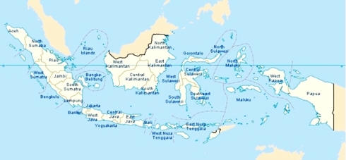
Map of Indonesia
Map of Indonesia

Administratively, Indonesia consists of 34 provinces, five of which have special status. Each province has its own legislature and governor. The provinces are subdivided into regencies (kabupaten) and cities (kota), which are further subdivided into districts (kecamatan), and again into village groupings (either desa or kelurahan). Furthermore, a village is divided into several citizen groups (Rukun-Warga (RW)) which are further divided into neighbourhood groups (Rukun-Tetangga (RT)). Following the implementation of regional autonomy measures in 2001, the regencies and cities have become the key administrative units, responsible for providing most government services. The village administration level is the most influential on a citizen’s daily life and handles matters of a village or neighborhood through an elected lurah or kepala desa (village chief).

The provinces of Aceh, Jakarta, Yogyakarta, Papua, and West Papua have greater legislative privileges and a higher degree of autonomy from the central government than the other provinces. The Acehnese government, for example, has the right to create certain elements of an independent legal system; in 2003, it instituted a form of Sharia (Islamic law).[82] Yogyakarta was granted the status of Special Region in recognition of its pivotal role in supporting Indonesian Republicans during the Indonesian Revolution.[83] Papua, formerly known as Irian Jaya, was granted special autonomy status in 2001 and was separated into Papua and West Papua in February 2003.[84][85] Jakarta is the country’s special capital region.

Indonesian Provinces and their Capitals, listed by Region

Indonesian name is in parentheses if different from English. * indicates provinces with Special Status

Sumatra

  1. Aceh* – Banda Aceh
  2. North Sumatra (Sumatera Utara) – Medan
  3. West Sumatra (Sumatera Barat) – Padang
  4. Riau – Pekanbaru
  5. Riau Islands (Kepulauan Riau) – Tanjung Pinang
  6. Jambi – Jambi (city)
  7. South Sumatra (Sumatera Selatan) – Palembang
  8. Bangka-Belitung (Kepulauan Bangka-Belitung) – Pangkal Pinang
  9. Bengkulu – Bengkulu (city)
  10. Lampung – Bandar Lampung

Java

  1. Special Capital Territory of Jakarta* (Daerah Khusus Ibu Kota Jakarta) – Jakarta
  2. Banten – Serang
  3. West Java (Jawa Barat) – Bandung
  4. Central Java (Jawa Tengah) – Semarang
  5. Yogyakarta Special Region* (Daerah Istimewa Yogyakarta) – Yogyakarta (city)
  6. East Java (Jawa Timur) – Surabaya

Lesser Sunda Islands

  1. Bali – Denpasar
  2. West Nusa Tenggara (Nusa Tenggara Barat) – Mataram
  3. East Nusa Tenggara (Nusa Tenggara Timur) – Kupang

Kalimantan

  1. West Kalimantan (Kalimantan Barat) – Pontianak
  2. Central Kalimantan (Kalimantan Tengah) – Palangkaraya
  3. South Kalimantan (Kalimantan Selatan) – Banjarmasin
  4. East Kalimantan (Kalimantan Timur) – Samarinda
  5. North Kalimantan (Kalimantan Utara) – Tanjung Selor

Sulawesi

  1. North Sulawesi (Sulawesi Utara) – Manado
  2. Gorontalo – Gorontalo (city)
  3. Central Sulawesi (Sulawesi Tengah) – Palu
  4. West Sulawesi (Sulawesi Barat) – Mamuju
  5. South Sulawesi (Sulawesi Selatan) – Makassar
  6. South East Sulawesi (Sulawesi Tenggara) – Kendari

Maluku Islands

  1. Maluku – Ambon
  2. North Maluku (Maluku Utara) – Sofifi

Western New Guinea

  1. West Papua* (Papua Barat) – Manokwari
  2. Papua* – Jayapura

Geography

Main article: Geography of Indonesia http://en.wikipedia.org/wiki/Geography_of_Indonesia

Indonesia lies between latitudes 11°S and 6°N, and longitudes 95°E and 141°E. It consists of 17,508 islands, about 6,000 of which are inhabited.[86] These are scattered over both sides of the equator. The largest are Java, Sumatra, Borneo (shared with Brunei and Malaysia), New Guinea (shared with Papua New Guinea), and Sulawesi. Indonesia shares land borders with Malaysia on Borneo, Papua New Guinea on the island of New Guinea, and East Timor on the island of Timor. Indonesia shares maritime borders across narrow straits with Singapore, Malaysia, the Philippines, and Palau to the north, and with Australia to the south. The capital, Jakarta, is on Java and is the nation’s largest city, followed by Surabaya, Bandung, Medan, and Semarang.[87]

Map of Indonesia
Map of Indonesia

At 1,919,440 square kilometers (741,050 sq mi), Indonesia is the world’s 16th-largest country in terms of land area.[88] Its average population density is 134 people per square kilometer (347 per sq mi), 79th in the world,[89] although Java, the world’s most populous island,[90] has a population density of 940 people per square kilometer (2,435 per sq mi). At 4,884 metres (16,024 ft), Puncak Jaya in Papua is Indonesia’s highest peak, and Lake Toba in Sumatra its largest lake, with an area of 1,145 square kilometers (442 sq mi). The country’s largest rivers are in Kalimantan, and include the Mahakam and Barito; such rivers are communication and transport links between the island’s river settlements.[91]

800px-Mahameru-volcano

Mount Semeru and Mount Bromo in East Java. Indonesia’s seismic and volcanic activity is among the world’s highest.

Indonesia’s location on the edges of the Pacific, Eurasian, and Australian tectonic plates makes it the site of numerous volcanoes and frequent earthquakes. Indonesia has at least 150 active volcanoes,[92] including Krakatoa and Tambora, both famous for their devastating eruptions in the 19th century. The eruption of the Toba supervolcano, approximately 70,000 years ago, was one of the largest eruptions ever, and a global catastrophe. Recent disasters due to seismic activity include the 2004 tsunami that killed an estimated 167,736 in northern Sumatra,[93] and the Yogyakarta earthquake in 2006. However, volcanic ash is a major contributor to the high agricultural fertility that has historically sustained the high population densities of Java and Bali.[94]

Lying along the equator, Indonesia has a tropical climate, with two distinct monsoonal wet and dry seasons. Average annual rainfall in the lowlands varies from 1,780–3,175 millimeters (70–125 in), and up to 6,100 millimeters (240 in) in mountainous regions. Mountainous areas—particularly in the west coast of Sumatra, West Java, Kalimantan, Sulawesi, and Papua—receive the highest rainfall. Humidity is generally high, averaging about 80%. Temperatures vary little throughout the year; the average daily temperature range of Jakarta is 26–30 °C (79–86 °F).[95]

Biota and Environment

Main articles: Fauna of Indonesia http://en.wikipedia.org/wiki/Fauna_of_Indonesia, Flora of Indonesia http://en.wikipedia.org/wiki/Flora_of_Indonesia, and Environment of Indonesia http://en.wikipedia.org/wiki/Environment_of_Indonesia

Myristica_fragrans_-_Köhler–s_Medizinal-Pflanzen-097The nutmeg plant is native to Indonesia’s Banda Islands. Once one of the world’s most valuable commodities, it drew the first European colonial powers to Indonesia.

Indonesia’s size, tropical climate, and archipelagic geography, support the world’s second highest level of biodiversity (after Brazil),[96] and its flora and fauna is a mixture of Asian and Australasian species.[97] The islands of the Sunda Shelf (Sumatra, Java, Borneo, and Bali) were once linked to the Asian mainland, and have a wealth of Asian fauna. Large species such as the tiger, rhinoceros, orangutan, elephant, and leopard, were once abundant as far east as Bali, but numbers and distribution have dwindled drastically. Forests cover approximately 60% of the country.[98] In Sumatra and Kalimantan, these are predominantly of Asian species. However, the forests of the smaller, and more densely populated Java, have largely been removed for human habitation and agriculture. Sulawesi, Nusa Tenggara, and Maluku—having been long separated from the continental landmasses—have developed their own unique flora and fauna.[99] Papua was part of the Australian landmass, and is home to a unique fauna and flora closely related to that of Australia, including over 600 bird species.[100]

Man_of_the_woodsThe critically endangered Sumatran Orangutan, a great ape endemic to Indonesia.

Indonesia is second only to Australia in terms of total endemic species, with 36% of its 1,531 species of bird and 39% of its 515 species of mammal being endemic.[101] Indonesia’s 80,000 kilometers (50,000 mi) of coastline are surrounded by tropical seas that contribute to the country’s high level of biodiversity. Indonesia has a range of sea and coastal ecosystems, including beaches, sand dunes, estuaries, mangroves, coral reefs, sea grass beds, coastal mudflats, tidal flats, algal beds, and small island ecosystems.[8] Indonesia is one of Coral Triangle countries with the world’s greatest diversity of coral reef fish with more than 1,650 species in eastern Indonesia only.[102] The British naturalist, Alfred Wallace, described a dividing line between the distribution and peace of Indonesia’s Asian and Australasian species.[103] Known as the Wallace Line, it runs roughly north-south along the edge of the Sunda Shelf, between Kalimantan and Sulawesi, and along the deep Lombok Strait, between Lombok and Bali. West of the line the flora and fauna are more Asian; moving east from Lombok, they are increasingly Australian. In his 1869 book, The Malay Archipelago, Wallace described numerous species unique to the area.[104] The region of islands between his line and New Guinea is now termed Wallacea.[103]

Indonesia’s high population and rapid industrialization present serious environmental issues, which are often given a lower priority due to high poverty levels and weak, under-resourced governance.[105] Issues include large-scale deforestation (much of it illegal) and related wildfires causing heavy smog over parts of western Indonesia, Malaysia and Singapore; over-exploitation of marine resources; and environmental problems associated with rapid urbanization and economic development, including air pollution, traffic congestion, garbage management, and reliable water and waste water services.[105] Deforestation and the destruction of peatlands make Indonesia the world’s third largest emitter of greenhouse gases.[106] Habitat destruction threatens the survival of indigenous and endemic species, including 140 species of mammals identified by the World Conservation Union (IUCN) as threatened, and 15 identified as critically endangered, including Bali Starling,[107] Sumatran Orangutan,[108] and Javan Rhinoceros.[107] Much of Indonesia’s deforestation is caused by forest clearing for the palm oil Industry, which has cleared 18 million hectares of forest for palm oil expansion. Palm oil expansion requires land reallocation as well as changes to the local and natural ecosystems. Palm oil expansion can generate wealth for local communities if done right. If down wrong it can degrade ecosystems and cause social conflicts.[109]

Economy

Main article: Economy of Indonesia http://en.wikipedia.org/wiki/Economy_of_Indonesia

KerbauJawaUsing water buffalo to plough rice fields in Java. Agriculture had been the country’s largest employer for centuries.

Indonesia has a mixed economy in which both the private sector and government play significant roles.[110] The country is the largest economy in Southeast Asia and a member of the G-20 major economies.[111] Indonesia’s estimated gross domestic product (nominal), as of 2010 was US$706.73 billion with estimated nominal per capita GDP was US$3,015, and per capita GDP PPP was US$4,394 (international dollars).[112] June 2011: At World Economic Forum on East Asia, Indonesian president said Indonesia will be in the top ten countries with the strongest economy within the next decade. The gross domestic product (GDP) is about $1 trillion[3] and the debt ratio to the GDP is 26%.[113] The industry sector is the economy’s largest and accounts for 46.4% of GDP (2010), this is followed by services (37.1%) and agriculture (16.5%). However, since 2010, the service sector has employed more people than other sectors, accounting for 48.9% of the total labor force, this has been followed by agriculture (38.3%) and industry (12.8%).[114] Agriculture, however, had been the country’s largest employer for centuries.[115][116]

According to World Trade Organization data, Indonesia was the 27th biggest exporting country in the world in 2010, moving up three places from a year before.[117] Indonesia’s main export markets (2009) are Japan (17.28%), Singapore (11.29%), the United States (10.81%), and China (7.62%). The major suppliers of imports to Indonesia are Singapore (24.96%), China (12.52%), and Japan (8.92%). In 2005, Indonesia ran a trade surplus with export revenues of US$83.64 billion and import expenditure of US$62.02 billion. The country has extensive natural resources, including crude oil, natural gas, tin, copper, and gold. Indonesia’s major imports include machinery and equipment, chemicals, fuels, and foodstuffs. And the country’s major export commodities include oil and gas, electrical appliances, plywood, rubber, and textiles.[118]

Jakarta

Jakarta, the capital of Indonesia and the country’s largest commercial center.

In the 1960s the economy deteriorated drastically as a result of political instability, a young and inexperienced government, and economic nationalism, which resulted in severe poverty and hunger. By the time of Sukarno’s downfall in the mid-1960s, the economy was in chaos with 1,000% annual inflation, shrinking export revenues, crumbling infrastructure, factories operating at minimal capacity, and negligible investment. Following President Sukarno’s downfall in the mid-1960s, the New Order administration brought a degree of discipline to economic policy that quickly brought inflation down, stabilized the currency, rescheduled foreign debt, and attracted foreign aid and investment. (See Berkeley Mafia). Indonesia was until recently Southeast Asia’s only member of OPEC, and the 1970s oil price raises provided an export revenue windfall that contributed to sustained high economic growth rates, averaging over 7% from 1968 to 1981.[119] Following further reforms in the late 1980s,[120] foreign investment flowed into Indonesia, particularly into the rapidly developing export-oriented manufacturing sector, and from 1989 to 1997, the Indonesian economy grew by an average of over 7%.[121][122]

Indonesia was the country hardest hit by the Asian financial crisis of 1997–98. During the crisis there were sudden and large capital outflows leading the rupiah to go into free fall. Against the US dollar the rupiah dropped from about Rp 2,600 in late 1997 to a low point of around Rp 17,000 some months later and the economy shrank by a remarkable 13.7%. These developments led to widespread economic distress across the economy and contributed to the political crisis of 1998 which saw Suharto resign as president.[123] The rupiah later stabilised in the Rp. 8,000-10,000 range[124] and a slow but steady economic recovery ensued. However political instability, slow economic reform, and corruption slowed the recovery.[6][7] Transparency International, for example, has since ranked Indonesia below 100 in its Corruption Perceptions Index.[125][126] Since 2007, however, with the improvement in banking sector and domestic consumption, national economic growth has accelerated to over 6% annually[127][128][129] and this helped the country weather the 2008–2009 global recession.[130] The Indonesian economy performed strongly during the Global Financial Crisis and in 2012 its GDP grew by over 6%.[131] The country regained its investment grade rating in late 2011 after losing it in the 1997.[132] However, as of 2010, an estimated 13.3% of the population lived below the poverty line and the official open unemployment rate was 7.1%.[118]

Demographics

Main articles: Demographics of Indonesia http://en.wikipedia.org/wiki/Demographics_of_Indonesia and List of endangered languages in Indonesia http://en.wikipedia.org/wiki/List_of_endangered_languages_in_Indonesia

Ubud-KidsBalinese children. There are around 300 distinct native ethnicities in Indonesia.

According to the 2010 national census, the population of Indonesia is 237.6 million,[133] with high population growth at 1.9%.[134] 58% of the population lives on Java,[133] the world’s most populous island.[90] In 1961 the first post-colonial census gave a total population of 97 million.[135] Despite a fairly effective family planning program that has been in place since the 1960s, population is expected to grow to around 265 million by 2020 and 306 million by 2050.[136]

There are around 300 distinct native ethnic groups in Indonesia, and 742 different languages and dialects.[137][138] Most Indonesians are descended from Austronesian-speaking peoples whose languages can be traced to Proto-Austronesian (PAn), which possibly originated in Taiwan. Another major grouping are Melanesians, who inhabit eastern Indonesia.[87][139] The largest ethnic group is the Javanese, who comprise 42% of the population, and are politically and culturally dominant.[140] The Sundanese, ethnic Malays, and Madurese are the largest non-Javanese groups.[141] A sense of Indonesian nationhood exists alongside strong regional identities.[142] Society is largely harmonious, although social, religious and ethnic tensions have triggered horrendous violence.[143][144][145] Chinese Indonesians are an influential ethnic minority comprising 3–4% of the population.[146] Much of the country’s privately owned commerce and wealth is Chinese-Indonesian-controlled,[147][148] which has contributed to considerable resentment, and even anti-Chinese violence.[149][150][151]

Istiqlal_MosqueThe Istiqlal Mosque in Central Jakarta. Indonesia is the world’s most populous Muslim-majority nation.

The official national language is Indonesian, a form of Malay. It is based on the prestige dialect of Malay, that of the Johor-Riau Sultanate, which for centuries had been the lingua franca of the archipelago, standards of which are the official languages in Singapore, Malaysia and Brunei. Indonesian is universally taught in schools, consequently it is spoken by nearly every Indonesian. It is the language of business, politics, national media, education, and academia. It was promoted by Indonesian nationalists in the 1920s, and declared the official language under the name Bahasa Indonesia on the proclamation of independence in 1945. Most Indonesians speak at least one of the several hundred local languages and dialects, often as their first language. Of these, Javanese is the most widely spoken as the language of the largest ethnic group.[118] On the other hand, Papua has over 270 indigenous Papuan and Austronesian languages,[152] in a region of about 2.7 million people.

While religious freedom is stipulated in the Indonesian constitution,[153] the government officially recognizes only six religions: Islam, Protestantism, Roman Catholicism, Hinduism, Buddhism, and Confucianism.[154] Although it is not an Islamic state, Indonesia is the world’s most populous Muslim-majority nation, with 87.2% of Indonesians being Muslim according to the 2010 census.[155] On 21 May 2011 the Indonesian Sunni-Shia Council (MUHSIN) was established. The council aims to hold gatherings, dialogues and social activities. It was an answer to violence committed in the name of religion.[156] The majority of Muslims in Indonesia are Sunni. 9% of the population was Christian, 3% Hindu, and 2% Buddhist or other. Most Indonesian Hindus are Balinese,[157] and most Buddhists in modern-day Indonesia are ethnic Chinese.[158] Though now minority religions, Hinduism and Buddhism remain defining influences in Indonesian culture. Islam was first adopted by Indonesians in northern Sumatra in the 13th century, through the influence of traders, and became the country’s dominant religion by the 16th century.[159] Roman Catholicism was brought to Indonesia by early Portuguese colonialists and missionaries,[160][161] and the Protestant denominations are largely a result of Dutch Calvinist and Lutheran missionary efforts during the country’s colonial period.[162][163][164] A large proportion of Indonesians—such as the Javanese abangan, Balinese Hindus, and Dayak Christians—practice a less orthodox, syncretic form of their religion, which draws on local customs and beliefs.[165]

Culture

Main article: Culture of Indonesia http://en.wikipedia.org/wiki/Culture_of_Indonesia

Wayang_PandawaWayang Kulit (shadow puppet) in Wayang Purwa type, depicting five Pandava, from left to right: Bhima, Arjuna, Yudhishtira, Nakula, and Sahadeva, Indonesia Museum, Jakarta.

Indonesia has about 300 ethnic groups, each with cultural identities developed over centuries, and influenced by Indian, Arabic, Chinese, and European sources. Traditional Javanese and Balinese dances, for example, contain aspects of Hindu culture and mythology, as do wayang kulit (shadow puppet) performances. Textiles such as batik, ikat, ulos and songket are created across Indonesia in styles that vary by region. The most dominant influences on Indonesian architecture have traditionally been Indian; however, Chinese, Arab, and European architectural influences have been significant.

Sports in Indonesia are generally male-orientated and spectator sports are often associated with illegal gambling.[166] The most popular sports are badminton and football. Indonesian players have won the Thomas Cup (the world team championship of men’s badminton) thirteen of the twenty-six times that it has been held since 1949, as well as numerous Olympic medals since the sport gained full Olympic status in 1992. Its women have won the Uber Cup, the female equivalent of the Thomas Cup, twice, in 1994 and 1996. Liga Indonesia is the country’s premier football club league. Traditional sports include sepak takraw, and bull racing in Madura. In areas with a history of tribal warfare, mock fighting contests are held, such as, caci in Flores, and pasola in Sumba. Pencak Silat is an Indonesian martial art.

Food_Sundanese_Restaurant,_JakartaA selection of Indonesian food, including roasted fish, nasi timbel (rice wrapped in banana leaf), sambal, fried tempeh and tofu, and sayur asem.

Indonesian cuisine varies by region and is based on Chinese, European, Middle Eastern, and Indian precedents.[167] Rice is the main staple food and is served with side dishes of meat and vegetables. Spices (notably chili), coconut milk, fish and chicken are fundamental ingredients.[168] Indonesian traditional music includes gamelan and keroncong. The Indonesian film industry’s popularity peaked in the 1980s and dominated cinemas in Indonesia,[169] although it declined significantly in the early 1990s.[170] Between 2000 and 2005, the number of Indonesian films released each year has steadily increased.[169]

The oldest evidence of writing in Indonesia is a series of Sanskrit inscriptions dated to the 5th century. Important figures in modern Indonesian literature include: Dutch author Multatuli, who criticized treatment of the Indonesians under Dutch colonial rule; Sumatrans Muhammad Yamin and Hamka, who were influential pre-independence nationalist writers and politicians;[171] and proletarian writer Pramoedya Ananta Toer, Indonesia’s most famous novelist.[172][173] Many of Indonesia’s peoples have strongly rooted oral traditions, which help to define and preserve their cultural identities.[174]

Media freedom in Indonesia increased considerably after the end of President Suharto’s rule, during which the now-defunct Ministry of Information monitored and controlled domestic media, and restricted foreign media.[175] The TV market includes ten national commercial networks, and provincial networks that compete with public TVRI. Private radio stations carry their own news bulletins and foreign broadcasters supply programs. At a reported 25 million users in 2008,[176] Internet usage was estimated at 12.5% in September 2009.[177] More than 30 million cell phones are sold in Indonesia each year, and 27 percent of them are local brands.[178]

Source: Wikipedia http://en.wikipedia.org/wiki/Indonesia for English Version and http://id.wikipedia.org/wiki/Indonesia for Bahasa Indonesia Version

Indonesia 01

Indonesia 02

Indonesia 03

Indonesia 04

“Indonesia Raya” is the national anthem of the Republic of Indonesia

INDONESIA RAYA

Indonesia tanah airku,
Tanah tumpah darahku,
Di sanalah aku berdiri,
Jadi pandu ibuku.

Indonesia kebangsaanku,
Bangsa dan tanah airku,
Marilah kita berseru,
Indonesia bersatu.

Hiduplah tanahku,
Hiduplah negeriku,
Bangsaku, Rakyatku, semuanya,
Bangunlah jiwanya,
Bangunlah badannya,
Untuk Indonesia Raya.

Refrain : 

Indonesia Raya,
Merdeka, merdeka,
Tanahku, neg’riku yang kucinta!
Indonesia Raya,
Merdeka, merdeka,
Hiduplah Indonesia Raya!

Isi Pancasila yang sesuai dengan Pasal UUD 1945

Sila Pertama: Ketuhanan Yang Maha Esa

Pasal Dalam UUD 1945: Pasal 29 dan pasal 28

Sila Kedua: Kemanusiaan Yang adil dan Beradab

Pasal pasal dalam UUD 1945: Pasal 28

Sila Ketiga: Persatuan Indonesia

Pasal-pasal dalam UUD 1945: Pasal 1 ayat 1, pasal 30 dan pasal 37 ayat 5

SilaKeempat:  Kerakyatan yang dipimpin oleh hikmat kebijaksaan dalam permusyawaratan perwakilan

Pasal-pasal dalam UUD 1945: Pasal 2, pasal 5, pasal 18, pasal 20, pasal 22

Sila Kelima: Keadilan Sosial bagi seluruh rakyat Indonesia

Pasal Pasal dalam UUD 1945: Pasal 28,pasal 33, dan pasal 34

Borobudur Temple Compounds

9 Mar

Borobudur Temple Compounds

Brief Description

This famous Buddhist temple, dating from the 8th and 9th centuries, is located in central Java. It was built in three tiers: a pyramidal base with five concentric square terraces, the trunk of a cone with three circular platforms and, at the top, a monumental stupa. The walls and balustrades are decorated with fine low reliefs, covering a total surface area of 2,500 m2. Around the circular platforms are 72 openwork stupas, each containing a statue of the Buddha. The monument was restored with UNESCO’s help in the 1970s.

Borobudur Temple Compounds 1
Borobudur © UNESCO  Outstanding Universal Value

Brief synthesis

The Borobudur Temple Compounds is one of the greatest Buddhist monuments in the world, and was built in the 8th and 9th centuries AD during the reign of the Syailendra Dynasty. The monument is located in the Kedu Valley, in the southern part of Central Java, at the centre of the island of Java, Indonesia.

The main temple is a stupa built in three tiers around a hill which was a natural centre: a pyramidal base with five concentric square terraces, the trunk of a cone with three circular platforms and, at the top, a monumental stupa. The walls and balustrades are decorated with fine low reliefs, covering a total surface area of 2,520 m2. Around the circular platforms are 72 openwork stupas, each containing a statue of the Buddha.

The vertical division of Borobudur Temple into base, body, and superstructure perfectly accords with the conception of the Universe in Buddhist cosmology. It is believed that the universe is divided into three superimposing spheres, kamadhatu, rupadhatu, and arupadhatu, representing respectively the sphere of desires where we are bound to our desires, the sphere of forms where we abandon our desires but are still bound to name and form, and the sphere of formlessness where there is no longer either name or form. At Borobudur Temple, the kamadhatu is represented by the base, the rupadhatu by the five square terraces, and the arupadhatu by the three circular platforms as well as the big stupa. The whole structure shows a unique blending of the very central ideas of ancestor worship, related to the idea of a terraced mountain, combined with the Buddhist concept of attaining Nirvana.

The Temple should also be seen as an outstanding dynastic monument of the Syailendra Dynasty that ruled Java for around five centuries until the 10th century.

The Borobudur Temple Compounds consists of three monuments: namely the Borobudur Temple and two smaller temples situatued to the east on a straight axis to Borobudur. The two temples are Mendut Temple, whose depiction of Buddha is represented by a formidable monolith accompanied by two Bodhisattvas, and Pawon Temple, a smaller temple whose inner space does not reveal which deity might have been the object of worship. Those three monuments represent phases in the attainment of Nirvana.

The temple was used as a Buddhist temple from its construction until sometime between the 10th and 15th centuries when it was abandoned. Since its re-discovery in the 19th century and restoration in the 20th century, it has been brought back into a Buddhist archaeological site.

Criterion (i): Borobudur Temple Compounds with its stepped, unroofed pyramid consisting of ten superimposing terraces, crowned by a large bell-shaped dome is a harmonious marriage of stupas, temple and mountain that is a masterpiece of Buddhist architecture and monumental arts.

Criterion (ii): Borobudur Temple Compounds is an outstanding example of Indonesia’s art and architecture from between the early 8th and late 9th centuries that exerted considerable influence on an architectural revival between the mid-13th and early 16th centuries.

Criterion (vi): Laid out in the form of a lotus, the sacred flower of Buddha, Borobudur Temple Compounds is an exceptional reflection of a blending of the very central idea of indigenous ancestor worship and the Buddhist concept of attaining Nirvana. The ten mounting terraces of the entire structure correspond to the successive stages that the Bodhisattva has to achieve before attaining to Buddhahood.

Integrity

The boundaries contain the three temples that include the imaginary axis between them. Although the visual links are no longer open, the dynamic function between the three monuments, Borobudur Temple, Mendut Temple, and Pawon Temple is maintained.

The main threat to the ensemble is from development that could compromise the extraordinary relationship between the main monument and its wider setting and could also affect the Outstanding Universal Value of the property. The approach to the property has to a degree already been compromised by weak developmental regulations.

Tourism also exerts considerable pressure on the property and its hinterland.

There is a growing rate of deterioration of the building stone, the cause of which needs further research. There is also a small degree of damage caused by unsupervised visitors.

The eruption of Mount Merapi is also considered as one of the potential threats because of its deposit acidic ash as happened in 2010.

Authenticity

The original materials were used to reconstruct the temple in two phases in the 20th century: after the turn of the century and more recently (1973-1983). Mostly original materials were used with some additions to consolidate the monument and ensure proper drainage which has not had any significant adverse impact on the value of the property. Though the present state of Borobudur Temple is the result of restorations, it retained more than enough original material when re-discovered to make a reconstruction possible.

Nowadays the property could be used as a Buddhist pilgrimage site. Its overall atmosphere is, however, to a certain degree compromised by the lack of control of commercial activities and the pressure resulting from the lack of an adequate tourism management strategy.

Protection and management requirements

The protection of the property is performed under Indonesian Law No. 11/2010 concerning Cultural Heritage and its surrounding cultural landscape. It is executed under a National Strategic Area and the Spatial Management Plan by the Ministry of Public Works in accordance with the Law concerning Spatial Management No. 26/2007 and Governmental Regulation No. 26/2008 concerning National Spatial Planning and will be enforced further by another presidential regulation regarding the Management for the Borobudur National Strategic Area that is still being drafted by the Ministry of Public Works.

The legal and institutional framework for the effective management of the property is regulated by a Presidential Decree Number 1 Year 1992. The established zones within the World Heritage property are respectively under the responsibility of the Borobudur Heritage Conservation Office under Ministry of Education and Culture, of state-owned institute PT. Taman Wisata Candi Borobudur under the Ministry of Enterprises, and of the local governments (Magelang Regency and Central Java Province). A study on the integrated management of Borobudur Temple Compounds has been conducted, including attention for the ecosystem, social and cultural aspects, ecotourism, public and private partnership and organisational feasibility study. This study is the basis of the still to be developed visitor management approach.

In order to ensure consistency between the 1992 Presidential Decree and the 1972 JICA Master Plan zone-system indicated in the World Heritage nomination dossier and to strengthen the regulations regarding development, a New Presidential Regulation is still being formulated by a Coordinating Board (14 Ministries and local authorities as well as representatives of local communities) and by formalizing the role of the proposed Management Board into the wider zones. In addition, the protection of the property has been ensured by the regular financial contribution by the national budget.

Monitoring programs has been effectively executed to monitor the growing rate of deterioration of building stone and also damage by unsupervised visitors. A research is being conducted to determine the long- term impact of deposit acidic ash of eruption of Mount Merapi to set further protection and conservation management of the property. Furthermore, a risk preparedness plan will be formulated in 2012.

The Borobudur Heritage Conservation Office has conducted community development programs targeting especially at the youth to raise their awareness. In improving and empowering local community as specialist guide for Borobudur Temple Compounds, several training programs have been conducted. The community development related to economical sector (small enterprises that produce traditional handicrafts, culinaries, etc) have already being conducted by the municipalities of Magelang Regency and Central Java Province.
Long Description

Borobudur is one of the greatest Buddhist monuments in the world. Founded by a king of the Saliendra dynasty, it was built to honour the glory of both the Buddha and its founder, a true king Bodhisattva. The name Borobudur is believed to have been derived from the Sanskrit words vihara Buddha uhr, meaning the Buddhist monastery on the hill. Borobudur temple is located in Muntilan, Magelang, and is about 42 km from Yogyakarta city.

This colossal temple was built between AD 750 and 842: 300 years before Cambodia’s Angkor Wat, 400 years before work had begun on the great European cathedrals. Little is known about its early history except that a huge army of workers worked in the tropical heat to shift and carve the 60,000 m3 of stone. At the beginning of the 11th century AD, because of the political situation in Central Java, divine monuments in that area, including the Borobudur Temple became completely neglected and given over to decay. The Sanctuary was exposed to volcanic eruption and other ravages of nature. The temple was not rediscovered until the 19th century. A first restoration campaign, supervised by Theodor van Erp, was undertaken shortly after the turn of the century. A second one was led more recently (1973-82).

A harmonious marriage of stupas, temple-mountain and the ritual diagram, this temple complex was built on several levels around a hill which forms a natural centre. The first level above the base comprises five square terraces, graduated in size and forming the base of a pyramid. Above this level are three concentric circular platforms crowned by the main stupa. Stairways provide access to this monumental stupa. The base and the balustrades enclosing the square terraces are decorated in reliefs sculpted in the stone. They illustrate the different phases of the soul’s progression towards redemption and episodes from the life of Buddha. The circular terraces are decorated with no fewer than 72 openwork stupas each containing a statue of Buddha.

Stylistically the art of Borobudur is a tributary of Indian influences (Gupta and post-Gupta styles). The walls of Borobudur are sculptured in bas-reliefs, extending over a total length of 6 km. It has been hailed as the largest and most complete ensemble of Buddhist reliefs in the world, unsurpassed in artistic merit, each scene an individual masterpiece. The narratives reliefs on the main walls read from the right to left, those on the balustrade from left to right. This was done for the purpose of the Pradaksina, the ritual circumambulation which the pilgrims make moving on the clockwise and keeping the sanctuary to the right.

The Karmawibangga reliefs on the hidden foot are devoted to the law of karma. The Lalitavistara series do not provide a complete biography of the Buddha, from the Hushita heaven and end his sermon in the Deer Park near the Benares. Jataka are stories about the Buddha before he was born as Prince Sidharta. Awadana are similar to Jataka, but the main figure is not the Boddhisatva, and the saintly deeds are attributed to other legendary persons.

The stories are compiled in the Dvijavadana (Glorious Heavenly Acts) and the Awadana Sataka (Hundred Awadanas). The first twenty panels in the lower series of the first gallery depict, the Sudhanakumaravadana. The series of reliefs covering the wall of the second gallery is devoted to Sudhana’s tireless wanderings in search of the Highest Perfect Wisdom. The story is continued on the wall and balustrade of the third and fourth galleries. Its depiction in most of the 460 panels is based on the holy Nahayana text Gandavyuha, the concluding scenes being derived from another text, the Badracari.

Source: UNESCO/CLT/WHC